Home > Europe > United Kingdom > England > Yorkshire > Allerton
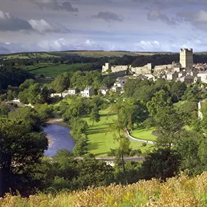
1840s Victorian Map Of North Riding Yorkshire

![]()
Wall Art and Photo Gifts from Mary Evans Picture Library
1840s Victorian Map Of North Riding Yorkshire
1840s, Victorian, Map, of, North, Riding, Yorkshire, Vintage, Lantern, Slide, York, Richmond, Allerton, Pickering, Malton, England, Edwardian, early, old, county, railway, railways, , 13934114
Mary Evans Picture Library makes available wonderful images created for people to enjoy over the centuries
Media ID 32350908
© Mary Evans Picture Library 2020
1840s Allerton Malton Pickering Railways Richmond
FEATURES IN THESE COLLECTIONS
> Europe
> United Kingdom
> England
> Maps
> Europe
> United Kingdom
> England
> Railways
> Europe
> United Kingdom
> England
> York
> Europe
> United Kingdom
> England
> Yorkshire
> Allerton
> Europe
> United Kingdom
> England
> Yorkshire
> Malton
> Europe
> United Kingdom
> England
> Yorkshire
> Pickering
> Europe
> United Kingdom
> England
> Yorkshire
> Richmond
> Maps and Charts
> Early Maps
> Mary Evans Prints Online
> New Images July 2023
EDITORS COMMENTS
Step back in time with this stunning vintage map of North Riding Yorkshire from the 1840s. This beautifully detailed piece captures the essence of Victorian England, showcasing towns such as York, Richmond, Allerton, Pickering, and Malton in exquisite detail.
The intricate railway lines crisscrossing the county are a testament to the industrial revolution that was sweeping through Britain during this era. Each line tells a story of progress and connectivity, linking communities together like never before.
As you gaze upon this Edwardian treasure, you can almost imagine what life was like in Yorkshire over a century ago. The bustling streets filled with horse-drawn carriages and people going about their daily lives. The grand architecture of York Minster standing tall against the skyline.
This map is not just a geographical representation but a window into history itself. It serves as a reminder of how far we have come since those early days of steam trains and gas lamps.
Whether you have roots in North Riding Yorkshire or simply appreciate the beauty of vintage maps, this lantern slide print is sure to captivate your imagination and transport you to another time. A true collector's item for anyone with an appreciation for history and heritage.
MADE IN AUSTRALIA
Safe Shipping with 30 Day Money Back Guarantee
FREE PERSONALISATION*
We are proud to offer a range of customisation features including Personalised Captions, Color Filters and Picture Zoom Tools
SECURE PAYMENTS
We happily accept a wide range of payment options so you can pay for the things you need in the way that is most convenient for you
* Options may vary by product and licensing agreement. Zoomed Pictures can be adjusted in the Cart.