Home > Europe > United Kingdom > England > Somerset > Axbridge
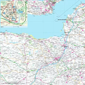
1840s Victorian Map of Somerset

![]()
Wall Art and Photo Gifts from Mary Evans Picture Library
1840s Victorian Map of Somerset
Mary Evans Picture Library makes available wonderful images created for people to enjoy over the centuries
Media ID 32350880
© The Keasbury-Gordon Photograph Archive / Mary Evans
1840s Bridgwater Dunster Minehead Porlock Railways Shepton Somerset Taunton Wells Axbridge Dulverton Mallett
FEATURES IN THESE COLLECTIONS
> Europe
> United Kingdom
> England
> Maps
> Europe
> United Kingdom
> England
> Railways
> Europe
> United Kingdom
> England
> Somerset
> Axbridge
> Europe
> United Kingdom
> England
> Somerset
> Bridgwater
> Europe
> United Kingdom
> England
> Somerset
> Dulverton
> Europe
> United Kingdom
> England
> Somerset
> Dunster
> Europe
> United Kingdom
> England
> Somerset
> Minehead
> Europe
> United Kingdom
> England
> Somerset
> Porlock
> Europe
> United Kingdom
> England
> Somerset
> Taunton
> Europe
> United Kingdom
> England
> Somerset
> Wells
> Mary Evans Prints Online
> New Images July 2023
EDITORS COMMENTS
Transport yourself back in time with this stunning 1840s Victorian Map of Somerset. This vintage map, captured on a lantern slide, showcases the intricate details of towns such as Minehead, Taunton, Bridgwater, Axbridge, Wells, Shepton Mallett, Dulverton, Porlock, and Dunster. Each corner of the county is meticulously depicted in this early Edwardian era print.
The map not only serves as a historical document but also highlights the importance of railways during that period in England. The railway lines crisscrossing through Somerset are clearly marked on the map, showcasing how transportation played a crucial role in connecting different parts of the county.
As you gaze upon this old map, you can almost imagine what life was like in Somerset during the 1840s. The attention to detail and craftsmanship evident in this print is truly remarkable and speaks to a bygone era where cartography was both an art form and a necessity for navigation.
Whether you have roots in Somerset or simply appreciate history and vintage maps, this 1840s Victorian Map of Somerset is sure to captivate your imagination and transport you back to a time when horse-drawn carriages roamed the streets and steam trains chugged along the tracks.
MADE IN AUSTRALIA
Safe Shipping with 30 Day Money Back Guarantee
FREE PERSONALISATION*
We are proud to offer a range of customisation features including Personalised Captions, Color Filters and Picture Zoom Tools
SECURE PAYMENTS
We happily accept a wide range of payment options so you can pay for the things you need in the way that is most convenient for you
* Options may vary by product and licensing agreement. Zoomed Pictures can be adjusted in the Cart.