Home > Europe > United Kingdom > England > Railways
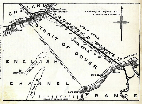
Map of proposed railway Channel Tunnel
![]()

Wall Art and Photo Gifts from Mary Evans Picture Library
Map of proposed railway Channel Tunnel
Map of proposed railway Channel Tunnel, Dover to Calais Date: circa 1850
Mary Evans Picture Library makes available wonderful images created for people to enjoy over the centuries
Media ID 32247666
© Mary Evans Picture Library
1850s Calais Channel Dover Maps Proposed Strait Tunnel
FEATURES IN THESE COLLECTIONS
> Architecture
> Tunnels
> Europe
> United Kingdom
> England
> Maps
> Europe
> United Kingdom
> England
> Railways
> Mary Evans Prints Online
> New Images July 2023
EDITORS COMMENTS
This map, dated circa 1850, depicts a proposed railway tunnel connecting Dover in England to Calais in France. The ambitious project, a precursor to the modern-day Chunnel, was a visionary endeavor of the Victorian era aimed at revolutionizing land and sea transportation between the two countries. The map, created during the height of the Industrial Revolution, illustrates the proposed railway line stretching beneath the English Channel, a seemingly insurmountable natural barrier. The meticulously drawn details of the map reveal the planned routes of the railway on both sides of the strait, with intricate labeling of towns, villages, and other geographical features. The map's intriguing title, "Proposed Railway Tunnel, Dover to Calais," highlights the innovative spirit of the time, as engineers and visionaries dared to dream of a subterranean railway that would bridge the gap between two nations. The map's creation predates the actual construction of the Channel Tunnel by over a century, making it a fascinating glimpse into the past and a testament to the ingenuity and ambition of the Victorian age. The map's rich historical significance is further enhanced by its beautiful and detailed cartography, with the use of intricate lines, shading, and color to depict the terrain on both sides of the Channel. The map's antique charm, combined with its historical importance, makes it a must-have for collectors of Victorian-era maps, railway history, and anyone with an interest in the fascinating story of human ingenuity and the quest to conquer the natural world.
MADE IN AUSTRALIA
Safe Shipping with 30 Day Money Back Guarantee
FREE PERSONALISATION*
We are proud to offer a range of customisation features including Personalised Captions, Color Filters and Picture Zoom Tools
SECURE PAYMENTS
We happily accept a wide range of payment options so you can pay for the things you need in the way that is most convenient for you
* Options may vary by product and licensing agreement. Zoomed Pictures can be adjusted in the Cart.


