Home > Europe > France > Paris > Maps
Paris, France - City Map

![]()
Wall Art and Photo Gifts from Mary Evans Picture Library
Paris, France - City Map
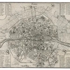
Paris, France - City Map Date: 1830
Mary Evans Picture Library makes available wonderful images created for people to enjoy over the centuries
Media ID 14158850
© Mary Evans Picture Library
FEATURES IN THESE COLLECTIONS
> Europe
> France
> Paris
> Maps
> Europe
> France
> Paris
> River Seine
> Maps and Charts
> Early Maps
EDITORS COMMENTS
1. Title: "A Glimpse into the Past: Paris, France - City Map (1830)" This antique map print transports us back in time to Paris, France, as it appeared in the year 1830. The intricately detailed map, showcasing the city's layout during the 19th century, is a testament to the rich history and evolution of one of the world's most iconic cities. The Seine River, meandering through the heart of Paris, is a prominent feature of this map. The river's importance to the city's development is evident as it served as a primary means of transportation and trade during this era. The map highlights various bridges, such as the Pont Neuf and the Pont Royal, which connected the left and right banks of the Seine, allowing for easier access to different parts of the city. Paris, in 1830, was a bustling metropolis, and this map provides a fascinating glimpse into its urban fabric. The city's major landmarks, including the Louvre Museum, Notre-Dame Cathedral, and the Palais Royal, are all clearly marked, offering a glimpse into the cultural and historical significance of these iconic structures. The map also reveals the city's administrative divisions, with various arrondissements (districts) labeled, providing insight into the organization and growth of Paris during this period. The intricate detailing of the map, from the winding streets to the labeled buildings, offers a unique perspective into the urban planning and architectural styles prevalent during the 19th century in Paris. This Paris, France - City Map (1830) is an essential historical document, offering a captivating window into the past and a reminder of the city's enduring allure. It serves as a valuable resource for historians, urban planners, and anyone with an interest in the history and development of Paris and Europe as a whole.
MADE IN AUSTRALIA
Safe Shipping with 30 Day Money Back Guarantee
FREE PERSONALISATION*
We are proud to offer a range of customisation features including Personalised Captions, Color Filters and Picture Zoom Tools
SECURE PAYMENTS
We happily accept a wide range of payment options so you can pay for the things you need in the way that is most convenient for you
* Options may vary by product and licensing agreement. Zoomed Pictures can be adjusted in the Cart.