Home > Europe > United Kingdom > England > London > Boroughs > Bexley
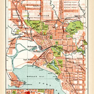
Street Map of Melbourne

![]()
Wall Art and Photo Gifts from Mary Evans Picture Library
Street Map of Melbourne
Black and white street map of Melbourne, Australia, showing major streets and railway station. Part of Box 100, Melbourne, Boswell Collection. Slide number 1. Date: circa 1890
Mary Evans Picture Library makes available wonderful images created for people to enjoy over the centuries
Media ID 14174064
© The Boswell Collection, Bexley Heritage Trust / Mary Evans
FEATURES IN THESE COLLECTIONS
> Europe
> United Kingdom
> England
> London
> Boroughs
> Bexley
> Maps and Charts
> Early Maps
> Oceania
> Australia
> Melbourne
EDITORS COMMENTS
1. Title: A Glimpse into Melbourne's Past: A Black and White Street Map of Australia's Cultural Hub from the Late 19th Century This black and white street map of Melbourne, Australia, offers a fascinating peek into the urban landscape of this vibrant city during the late 19th century. Dating back to approximately 1890, this intricately detailed map is part of the Boswell Collection, Box 100, and slide number 1, held by Mary Evans Prints Online. Melbourne, the second-largest city in Australia, has a rich history that dates back to the early 19th century. By the late 1800s, it had grown into a bustling metropolis, with a well-developed infrastructure of major streets and transportation systems. This map illustrates the city's growth and expansion during this period, highlighting its primary thoroughfares and key landmarks. The map reveals the central business district (CBD) as the heart of Melbourne, with its grid-like streets radiating outwards. Major roads such as Bourke, Collins, and Swanston Streets are clearly marked, as are the city's railway stations, including Flinders Street and Melbourne Central. The Yarra River, which winds its way through the city, is also depicted, adding to the map's authenticity. This historical artifact provides an invaluable resource for researchers, historians, and anyone interested in the history of Melbourne and Australia. It offers a unique perspective on the city's development and growth during the late 19th century, a time when Melbourne was establishing itself as a cultural and economic hub in the region. In conclusion, this black and white street map of Melbourne is an essential piece of Australian history, offering a glimpse into the city's past and its transformation from a small settlement into a thriving metropolis. It serves as a testament to the city's rich heritage and its enduring significance in the history of Australia.
MADE IN AUSTRALIA
Safe Shipping with 30 Day Money Back Guarantee
FREE PERSONALISATION*
We are proud to offer a range of customisation features including Personalised Captions, Color Filters and Picture Zoom Tools
FREE COLORIZATION SERVICE
You can choose advanced AI Colorization for this picture at no extra charge!
SECURE PAYMENTS
We happily accept a wide range of payment options so you can pay for the things you need in the way that is most convenient for you
* Options may vary by product and licensing agreement. Zoomed Pictures can be adjusted in the Cart.