Home > North America > United States of America > New York > New York > Maps
USNY2A-00037

![]()
Wall Art and Photo Gifts from North Wind
USNY2A-00037
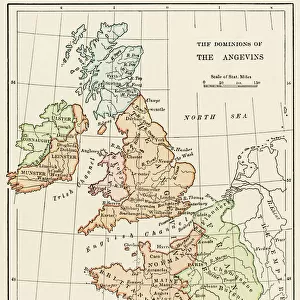
Bellins map of the New York Bay, 1764.
Hand-colored woodcut reproduction of an 18th-century illustration
North Wind Picture Archives brings history to life with stock images and hand-colored illustrations
Media ID 5882563
© North Wind Picture Archives
1700s 1760s 18th Century Atlantic Atlantic Ocean Chart Colonial Colonist Colony English English Colony Harbor Manhattan New Jersey New York New York City 1764 Bellin Long Island Sandy Hook Staten Island
FEATURES IN THESE COLLECTIONS
> North America
> United States of America
> New York
> New York
> Manhattan
> Related Images
> North America
> United States of America
> New York
> New York
> Maps
> North America
> United States of America
> New York
> New York
> Staten Island
> Related Images
> North Wind Picture Archives
> Maps
> North Wind Picture Archives
> New York City
EDITORS COMMENTS
This print showcases a hand-colored woodcut reproduction of Bellin's map of the New York Bay from 1764. Steeped in history and brimming with intricate details, this vintage illustration takes us back to the vibrant days of colonial America. The map depicts the sprawling bay, encompassing iconic landmarks such as Manhattan, Staten Island, Long Island, and even Sandy Hook. As we delve into its depths, we are transported to a time when English colonists first set foot on these shores. With its rich hues and meticulous craftsmanship, this 18th-century artwork serves as a testament to our American heritage. It offers an invaluable glimpse into the past while highlighting the significance of New York City as a bustling hub for trade and exploration during that era. As we trace our fingers along its lines and contours, we can almost feel the excitement that must have coursed through those early settlers. The map not only captures the geography but also tells stories of discovery and growth in North America. Its presence evokes a sense of pride for our nation's roots while reminding us how far we've come since then. This remarkable piece is more than just an artistic representation; it is a window into our collective history—a tangible connection between past and present that deserves admiration
MADE IN AUSTRALIA
Safe Shipping with 30 Day Money Back Guarantee
FREE PERSONALISATION*
We are proud to offer a range of customisation features including Personalised Captions, Color Filters and Picture Zoom Tools
SECURE PAYMENTS
We happily accept a wide range of payment options so you can pay for the things you need in the way that is most convenient for you
* Options may vary by product and licensing agreement. Zoomed Pictures can be adjusted in the Cart.