Home > Sheffield City Archives > Maps and Plans > John Speed's County Maps, 1611
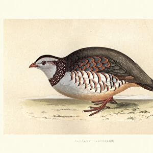
John Speed's map of Great Britain and Ireland, 1611

![]()
Wall Art and Photo Gifts from Sheffield City Archives
John Speed's map of Great Britain and Ireland, 1611
The British Isles
Image from Theatre of the Empire of Great Britaine presenting an exact geography of the Kingdomes of Ireland, Scotland, Ireland, and the Iles adioyning with The Shires, Hundreds, Cities and Shire Towns, within ye Kingdome of England, divided and described by John Speed (original at Sheffield Libraries: 914.2 SQ).
Note this image is of a genuine 400-year-old map from a tightly bound volume. It shows some wear and tear as well as the binding in the middle of the image
Sheffield City Archives and Local Studies Library has an unrivalled collection of images of Sheffield, England
Media ID 26401730
© Sheffield City Council - All Rights Reserved
FEATURES IN THESE COLLECTIONS
> Sheffield City Archives
> Maps and Plans
> John Speed's County Maps, 1611
> Sheffield City Archives
> Maps and Plans
> Maps of Ireland
> Sheffield City Archives
> Maps and Plans
> Maps of Scotland
> Sheffield City Archives
> Maps and Plans
> Maps of Wales
EDITORS COMMENTS
This print showcases John Speed's map of Great Britain and Ireland, dating back to the year 1611. The image is sourced from Theatre of the Empire of Great Britaine, a remarkable work that presents an accurate geography of the Kingdoms of England, Scotland, and Ireland, along with their surrounding islands. Preserved in Sheffield Libraries' collection (914.2 SQ), this genuine 400-year-old map offers a glimpse into the rich history and intricate details of these lands. Despite its age, this extraordinary piece exhibits signs of wear and tear that bear witness to its journey through time. The binding in the middle serves as a reminder that it was once part of a tightly bound volume cherished by generations past. As we delve into this mesmerizing artwork, we are transported back to an era where cartography played a crucial role in understanding and navigating our world. It is important to note that this image should not be associated with any commercial use or company; rather it stands as a testament to the historical significance held within Sheffield City Archives' vast collection. This photograph invites us to appreciate both the craftsmanship involved in creating such maps centuries ago and their enduring value as cultural artifacts today.
MADE IN AUSTRALIA
Safe Shipping with 30 Day Money Back Guarantee
FREE PERSONALISATION*
We are proud to offer a range of customisation features including Personalised Captions, Color Filters and Picture Zoom Tools
SECURE PAYMENTS
We happily accept a wide range of payment options so you can pay for the things you need in the way that is most convenient for you
* Options may vary by product and licensing agreement. Zoomed Pictures can be adjusted in the Cart.


![British Railways - Broad Green Station New Booking Office Plan and Elevation [1974]](/sq/229/british-railways-broad-green-station-new-19157019.jpg.webp)