Home > Sheffield City Archives > Maps and Plans > John Speed's County Maps, 1611
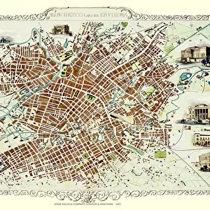
John Speeds map of Lancashire, 1611

![]()
Wall Art and Photo Gifts from Sheffield City Archives
John Speeds map of Lancashire, 1611
Image from Theatre of the Empire of Great Britaine presenting an exact geography of the Kingdomes of Ireland, Scotland, Ireland, and the Iles adioyning with The Shires, Hundreds, Cities and Shire Towns, within ye Kingdome of England, divided and described by John Speed (original at Sheffield Libraries: 914.2 SQ).
Note this image is of a genuine 400-year-old map from a tightly bound volume. It shows some wear and tear as well as the binding in the middle of the image
Sheffield City Archives and Local Studies Library has an unrivalled collection of images of Sheffield, England
Media ID 26401424
© Sheffield City Council - All Rights Reserved
EDITORS COMMENTS
This print showcases John Speed's map of Lancashire, dating back to the year 1611. Extracted from his renowned work "Theatre of the Empire of Great Britaine" this image offers a glimpse into an era long gone by. Preserved within Sheffield Libraries' collection (914.2 SQ), this genuine 400-year-old map is a testament to the rich history and cultural heritage it represents. Despite its age, the map bears visible signs of wear and tear, which only adds to its authenticity and charm. The binding in the middle serves as a reminder that this piece was once part of a tightly bound volume, cherished for centuries by those who sought knowledge or adventure through cartography. As we explore this remarkable artifact, we are transported back in time to an England divided into shires, hundreds, cities, and shire towns—each meticulously described by John Speed himself. This intricate geography extends beyond England's borders to encompass Ireland, Scotland, and neighboring islands. While admiring this rare find from Sheffield City Archives' treasure trove, let us appreciate not only its historical significance but also the dedication required to preserve such valuable relics for future generations. This image is not intended for commercial use; rather it stands as a testament to our collective past—a window into an age where maps were both navigational tools and works of art capturing the essence of a nation's identity.
MADE IN AUSTRALIA
Safe Shipping with 30 Day Money Back Guarantee
FREE PERSONALISATION*
We are proud to offer a range of customisation features including Personalised Captions, Color Filters and Picture Zoom Tools
SECURE PAYMENTS
We happily accept a wide range of payment options so you can pay for the things you need in the way that is most convenient for you
* Options may vary by product and licensing agreement. Zoomed Pictures can be adjusted in the Cart.