Home > Arts > Portraits > Pop art gallery > Street art portraits
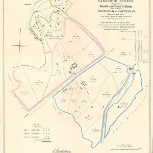
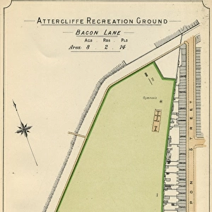
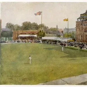
Plan of Carbrook Recreation Ground, 1897

![]()
Wall Art and Photo Gifts from Sheffield City Archives
Plan of Carbrook Recreation Ground, 1897
Image from Sheffield City Council, General Purposes and Parks Committee - Plans and Description of Parks and Recreation Grounds (Local Studies Library 352.7 SQ)
Sheffield City Archives and Local Studies Library has an unrivalled collection of images of Sheffield, England
Media ID 14047340
© Sheffield City Council
Attercliffe Carbrook Cricket Facilities Football Gardens Ground Maps Park Parks Road Sports Street Grounds Terry
FEATURES IN THESE COLLECTIONS
> Arts
> Portraits
> Pop art gallery
> Street art portraits
> Maps and Charts
> Related Images
> Sheffield City Archives
> Maps and Plans
> Sport
> Cricket
> Related Images
> Sport
> Football
> Soccer
> Related Images
EDITORS COMMENTS
This print takes us back in time to the year 1897, showcasing the intricate "Plan of Carbrook Recreation Ground". Preserved by Sheffield City Council's General Purposes and Parks Committee, this image offers a glimpse into the history of one of Sheffield's cherished green spaces. The photograph highlights a meticulously designed layout that encompasses various elements essential for recreational activities. The Carbrook Recreation Ground appears as a vibrant hub for sports enthusiasts, with its football grounds, cricket playing fields, and other sports facilities prominently marked on the plan. These areas served as gathering spots where locals could engage in friendly matches or simply enjoy their favorite pastimes. Nestled within Attercliffe and Carbrook neighborhoods, this park was undoubtedly an integral part of community life during those times. Its strategic location near Common Street and Terry Gardens made it easily accessible to residents who sought solace amidst nature's beauty. As we explore this historical document further, we can't help but appreciate how meticulously planned every detail is - from the carefully laid-out paths to the thoughtfully positioned gardens. This map provides invaluable insights into urban planning practices prevalent at that time. Thanks to Sheffield City Archives' dedication towards preserving such valuable records, we are granted a unique opportunity to delve into our city's rich heritage. Let us cherish these glimpses from the past and honor those who have worked tirelessly to maintain our parks for generations to come.
MADE IN AUSTRALIA
Safe Shipping with 30 Day Money Back Guarantee
FREE PERSONALISATION*
We are proud to offer a range of customisation features including Personalised Captions, Color Filters and Picture Zoom Tools
SECURE PAYMENTS
We happily accept a wide range of payment options so you can pay for the things you need in the way that is most convenient for you
* Options may vary by product and licensing agreement. Zoomed Pictures can be adjusted in the Cart.