Home > Europe > United Kingdom > England > Yorkshire > Sheffield
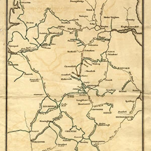
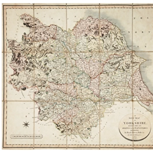
West Riding of Yorkshire, 1834

![]()
Wall Art and Photo Gifts from Sheffield City Archives
West Riding of Yorkshire, 1834
By Archibald Fullerton.Scale 20 miles : 1 1/4 inches.Original at Local Studies Library: E11VS
Sheffield City Archives and Local Studies Library has an unrivalled collection of images of Sheffield, England
Media ID 14047413
© Sheffield City Council
FEATURES IN THESE COLLECTIONS
> Europe
> United Kingdom
> England
> West Yorkshire
> Related Images
> Europe
> United Kingdom
> England
> Yorkshire
> Related Images
> Europe
> United Kingdom
> England
> Yorkshire
> Sheffield
> Maps and Charts
> Related Images
> Sheffield City Archives
> Maps and Plans
EDITORS COMMENTS
This print showcases the West Riding of Yorkshire in 1834, meticulously crafted by Archibald Fullerton. With a scale of 20 miles to 1 1/4 inches, this detailed map offers an intriguing glimpse into the past. Preserved at the esteemed Local Studies Library: E11VS within Sheffield City Archives, it serves as a testament to the historical significance and cultural heritage of this region. The image captures the essence of rural life during that era, depicting sprawling landscapes dotted with charming villages and bustling market towns. The intricate details on this map allow us to explore every nook and cranny of West Riding, from its rolling hills and meandering rivers to its ancient forests and picturesque valleys. Archibald Fullerton's expertise shines through in his meticulous cartography skills, showcasing not only geographical accuracy but also capturing important landmarks such as castles, churches, and bridges that were integral parts of daily life back then. As we delve into this remarkable piece of history preserved within Sheffield City Archives' collection, we are transported back in time. It is a visual journey that invites us to imagine what life was like for our ancestors who once called these lands home. This print is more than just a mere representation; it is a window into an era long gone yet forever etched in our collective memory. Its presence reminds us of the rich tapestry woven by generations before us—a reminder to cherish our roots while embracing progress and change.
MADE IN AUSTRALIA
Safe Shipping with 30 Day Money Back Guarantee
FREE PERSONALISATION*
We are proud to offer a range of customisation features including Personalised Captions, Color Filters and Picture Zoom Tools
SECURE PAYMENTS
We happily accept a wide range of payment options so you can pay for the things you need in the way that is most convenient for you
* Options may vary by product and licensing agreement. Zoomed Pictures can be adjusted in the Cart.
![[South] Part of the West Riding of Yorkshire, 1796](/sq/716/south-west-riding-yorkshire-1796-14047414.jpg.webp)