
Maps Collection
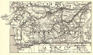
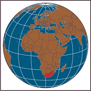
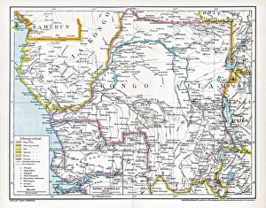
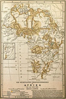
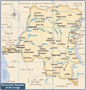
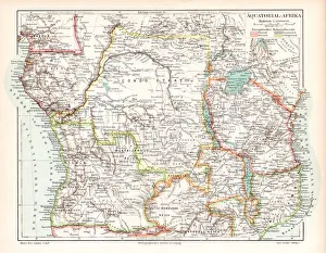
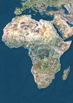
The Republic of the Congo is a country located in Central Africa, and is bordered by Gabon, Cameroon, the Central African Republic
Choose a picture from our Maps Collection for your Wall Art and Photo Gifts
12 items
All Professionally Made to Order for Quick Shipping
-
Maps Collection
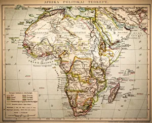
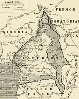
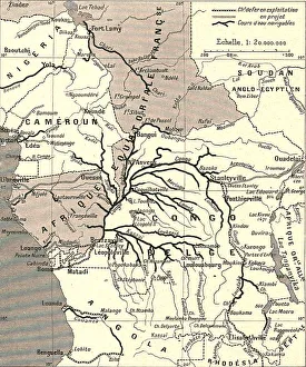
The Republic of the Congo is a country located in Central Africa, and is bordered by Gabon, Cameroon, the Central African Republic, the Democratic Republic of the Congo and Angola. The capital and largest city is Brazzaville. The terrain consists mostly of coastal plains in the south that rise to a plateau in the north. The climate is tropical with two distinct seasons: wet season from March to June and dry season from July to February. Major rivers include Congo River, Ubangi River and Sangha River which are used for transportation purposes as well as fishing industry. Natural resources include petroleum, timber, potash, lead, zinc and uranium while agriculture includes cassava (manioc), plantains bananas yams maize peanuts sugarcane coffee cocoa beans palm oil rubber cotton tea tobacco livestock fish forestry mining industry manufacturing sector services sector tourism sector are also important economic activities in this country.
+
Our beautiful pictures are available as Framed Prints, Photos, Wall Art and Photo Gifts
Media Storehouse offers a collection of Maps of Republic of the Congo Africa, which includes wall art and framed prints. Our collection features a variety of maps that showcase the geography, topography, and political boundaries of the country. These maps are designed to provide an informative and decorative addition to any home or office space. The Maps of Republic of the Congo Africa collection is ideal for those who have an interest in African geography or history. The maps are also useful for educational purposes as they can be used by teachers to teach students about various aspects related to this region. The our Maps of Republic of the Congo Africa collection is available in different sizes and styles, making it easy for customers to find something that suits their preferences. Additionally, all products are made with high-quality materials ensuring durability and longevity. Our collection provides a unique opportunity for individuals interested in exploring African geography through stunning visual representations.
+
What are Maps of Republic of the Congo Africa art prints?
Maps of Republic of the Congo Africa art prints are high-quality reproductions of maps that depict the geography and topography of the Republic of Congo. These maps showcase various features such as rivers, mountains, cities, and other landmarks that are significant to the country's history and culture. These art prints are perfect for those who have an interest in cartography or African geography. They can be used to decorate homes, offices, or classrooms and serve as educational tools for students studying African geography. Maps of Republic of the Congo Africa art prints come in a variety of sizes and styles to suit different preferences. Some may prefer vintage-style maps while others may prefer more modern designs. Regardless of style preference, these art prints offer a unique way to appreciate the beauty and complexity of this fascinating country. Maps of Republic of the Congo Africa art prints provide an excellent opportunity for individuals to learn about this beautiful country while adding a touch of sophistication to their living spaces.
+
What Maps of Republic of the Congo Africa art prints can I buy from Media Storehouse?
We offer a wide range of Republic of the Congo Africa art prints that you can purchase. These maps are perfect for those who love geography or want to decorate their homes with unique and beautiful artwork. You can choose from various styles, including vintage, modern, and artistic interpretations. Some popular options include detailed topographic maps that showcase the country's natural features such as rivers, mountains, and forests. Additionally, there are political maps that highlight major cities and administrative regions within the country. If you're looking for something more abstract or artistic, Media Storehouse also offers creative map designs that incorporate vibrant colors and patterns inspired by African culture. No matter what your preference is, these Republic of the Congo Africa art prints are sure to add character and style to any room in your home or office.
+
How do I buy Maps of Republic of the Congo Africa art prints?
To buy Maps of Republic of the Congo Africa art prints from Media Storehouse, you can browse our extensive collection online. We offer a range of sizes and framing options to suit your preferences. Once you have found the print you would like to purchase, simply add it to your cart and proceed to checkout. You will be prompted to enter your shipping and payment details before completing the transaction. Media Storehouse is committed to providing high-quality art prints that are both affordable and visually stunning. Their selection includes a variety of styles, from classic maps to contemporary designs, so there is something for everyone. Whether you are looking for a unique piece of wall art or a thoughtful gift for someone special, we have everything you need. With fast and reliable shipping options available worldwide, buying Maps of Republic of the Congo Africa art prints has never been easier.
+
How much do Maps of Republic of the Congo Africa art prints cost?
We offer a wide range of Maps of Republic of the Congo Africa art prints that vary in cost depending on several factors. The size and type of print can affect the price, as well as any additional customization options such as framing or matting. Additionally, some prints may be more rare or unique than others which can also impact their cost. We strive to provide our customers with high-quality art prints at competitive prices while maintaining ethical business practices. Our selection includes a variety of styles and designs to suit different tastes and preferences. If you are interested in purchasing a Maps of Republic of the Congo Africa art print from Media Storehouse, we encourage you to browse our collection online or contact us for further assistance. We are committed to helping you find the perfect piece for your home or office decor needs without breaking your budget.
+
How will my Maps of Republic of the Congo Africa art prints be delivered to me?
We take great care in ensuring that your Maps of Republic of the Congo Africa art prints are delivered to you safely and securely. We use high-quality packaging materials to protect your artwork during transit, including sturdy cardboard tubes and protective sleeves. Once your order has been processed, it will be carefully packaged by our team and dispatched for delivery using a trusted courier service. You will receive a tracking number so that you can keep an eye on the progress of your delivery. We understand how important it is for your artwork to arrive in perfect condition, which is why we take every precaution possible to ensure its safe arrival. If for any reason there are issues with the delivery or if you have any questions about the process, our customer service team is always available to assist you.