Fraud Blocker Skip to main content

Home > Africa > South Africa > Maps

Maps Collection (page 3)

South Africa is a large and diverse country, with many different landscapes

399 items

Background imageMaps Collection: Development of the British Empire, lithograph, published 1897

Development of the British Empire, lithograph, published 1897
Map of the territorial development of the British Empire from the 17th century to the end of the 19th century. Lithograph, published in 1897

Background imageMaps Collection: Topographic maps of the former German colonies, lithograph, published 1897

Topographic maps of the former German colonies, lithograph, published 1897
Topographic maps of the former German colonies in Africa and the South Seas. Lithograph, published in 1897

Background imageMaps Collection: Historical map of Cape Town; South Africa, wood engraving, published 1897

Historical map of Cape Town; South Africa, wood engraving, published 1897
Historical map of Cape Town; South Africa. Wood engraving, published in 1897

Background imageMaps Collection: Map of the Shangani Patrol and Major Wilsons Last Stand

Map of the Shangani Patrol and Major Wilsons Last Stand
Vintage engraving of a Map of the Shangani Patrol and Major Wilsons Last Stand. The Shangani Patrol (or Wilsons Patrol), comprising 34 soldiers in the service of the British South Africa Company

Background imageMaps Collection: Map from Peter Kolbes Cape of Good Hope, 1719, 1719, (1931). Artist: Peter Kolbe

Map from Peter Kolbes Cape of Good Hope, 1719, 1719, (1931). Artist: Peter Kolbe
Map from Peter Kolbes Cape of Good Hope, 1719, 1719, (1931). From Historic Farms of South Africa by Dorothea Fairbridge. [Oxford University Press, London, 1931]

Background imageMaps Collection: Map of Africa 1877

Map of Africa 1877
Warrens Common School Geography 1877

Background imageMaps Collection: 13885125

13885125

Background imageMaps Collection: 13885092

13885092

Background imageMaps Collection: 13884449

13884449

Background imageMaps Collection: 13873501

13873501

Background imageMaps Collection: 13872496

13872496

Background imageMaps Collection: 13871548

13871548

Background imageMaps Collection: 13871547

13871547

Background imageMaps Collection: 13871181

13871181

Background imageMaps Collection: 13871068

13871068

Background imageMaps Collection: 13867872

13867872

Background imageMaps Collection: 13860957

13860957

Background imageMaps Collection: 13856732

13856732

Background imageMaps Collection: 13853934

13853934

Background imageMaps Collection: 13853298

13853298

Background imageMaps Collection: 13849201

13849201

Background imageMaps Collection: 13834793

13834793

Background imageMaps Collection: 13834774

13834774

Background imageMaps Collection: 13834759

13834759

Background imageMaps Collection: 13828220

13828220

Background imageMaps Collection: 13826674

13826674

Background imageMaps Collection: 13826603

13826603

Background imageMaps Collection: 13826524

13826524

Background imageMaps Collection: 13821873

13821873

Background imageMaps Collection: 13821767

13821767

Background imageMaps Collection: 13819337

13819337

Background imageMaps Collection: 13819072

13819072

Background imageMaps Collection: A Map of New Zealand

A Map of New Zealand
A truly outstanding, and large scale, Empire Marketing Board poster map designed by Leslie MacDonald ('Max') Gill. This design, for New Zealand, was published in 1930

Background imageMaps Collection: Post Office Radio Telephone Services and Fisheries

Post Office Radio Telephone Services and Fisheries
A wonderful, original, poster map showing Post Office Radio Telephone Services commissioned by the General Post Office and designed by Leslie MacDonald Gill, 1935

Background imageMaps Collection: A Map Of Irish Free State And Northern Ireland

A Map Of Irish Free State And Northern Ireland
a, map, of, irish, free, state, and, northern, ireland, 1929, truly, outstanding, large, scale, empire, marketing, board, poster, designed, by, leslie, macdonald, max, gill, this, design, for,

Background imageMaps Collection: Advert, Union-Castle Line, South Africa

Advert, Union-Castle Line, South African steamships Date: 1937

Background imageMaps Collection: Poster marking returning soldiers from the Boer war

Poster marking returning soldiers from the Boer war
Poster marking returning soldiers from the second Boer war ( 11 Oct 1899 ?? 31 May 1902) Also known as the Boer War, Anglo-Boer War, or South African War

Background imageMaps Collection: Official anti British First Boer War protest card

Official anti British First Boer War protest card
A conflict known also as the Transvaal Rebellion took place between the British and the Boers from 1880 to 1881 The south of Africa was overlaid with European powers competing for colonial territory

Background imageMaps Collection: Map of the Boer Republics at the end of the 19th century, from South Africa and the Transvaal War

Map of the Boer Republics at the end of the 19th century, from South Africa and the Transvaal War: Vol
KW371000 Map of the Boer Republics at the end of the 19th century, from South Africa and the Transvaal War: Vol. 1 by Louis Creswicke, published 1900 (litho) by English School

Background imageMaps Collection: Map of Matabeleland in the late 19th century, from South Africa and the Transvaal War: Vol

Map of Matabeleland in the late 19th century, from South Africa and the Transvaal War: Vol
KW371011 Map of Matabeleland in the late 19th century, from South Africa and the Transvaal War: Vol. 1 by Louis Creswicke, published 1900 (litho) by English School, (20th century); Private Collection

Background imageMaps Collection: Map of Zululand and adjoining portions of Natal at the end of the 19th century

Map of Zululand and adjoining portions of Natal at the end of the 19th century
KW371004 Map of Zululand and adjoining portions of Natal at the end of the 19th century, from South Africa and the Transvaal War: Vol

Background imageMaps Collection: 3671023

3671023

Background imageMaps Collection: Historic Map of Cape Town, South Africa, Historic, digitally restored reproduction of an original

Historic Map of Cape Town, South Africa, Historic, digitally restored reproduction of an original 19th century map
1900s, 19th-century, art work, arts, artwork, artworks, big city, black, black-and-white, black-white, cities, depiction, depictions, deserted, digital, digitally, drawing, drawings, drawn, early

Background imageMaps Collection: Union of South Africa, Australia, New Zealand, from the series Where Our Exports Go

Union of South Africa, Australia, New Zealand, from the series Where Our Exports Go, 1927 [6321242] (colour litho)
MAN452963 Union of South Africa, Australia, New Zealand, from the series Where Our Exports Go, 1927 [6321242] (colour litho) by Grimmond, William (1884-1952); Manchester Art Gallery

Background imageMaps Collection: Old Map of South Africa, detail of Cape Town, Transvaal, Cape Colony, Orange Free State, 1890s

Old Map of South Africa, detail of Cape Town, Transvaal, Cape Colony, Orange Free State, 1890s, 19th Century
Vintage illustration Old Map of South Africa, detail of Cape Town, Transvaal, Cape Colony, Orange Free State, 1890s, 19th Century

Background imageMaps Collection: Vintage illustration Old Map of South Africa, Cape Colony, 1890s, 19th Century

Vintage illustration Old Map of South Africa, Cape Colony, 1890s, 19th Century

Background imageMaps Collection: Map of Australasia (1882 engraving)

Map of Australasia (1882 engraving)
Old map of Australasia from "Royal Geographical Readers no. 5" of Asia, Africa, America and Oceania, publ. T Nelson & Sons, London in 1883

Background imageMaps Collection: Old chromolithograph map of South Africa - Cape Colony and Natal provinces, Namibia - coast British

Old chromolithograph map of South Africa - Cape Colony and Natal provinces, Namibia - coast British
Antique Maps


All Professionally Made to Order for Quick Shipping


-

Maps Collection

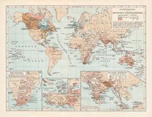
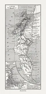
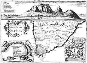
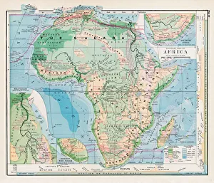
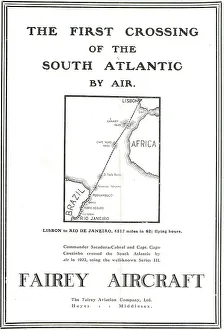
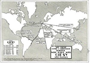
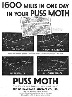
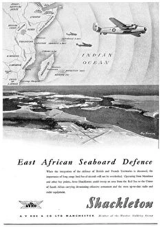
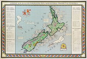
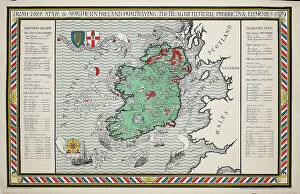
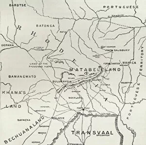
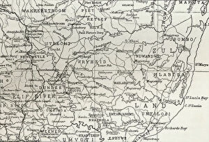
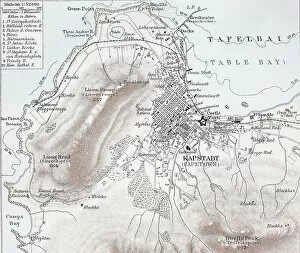
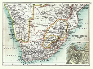
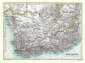
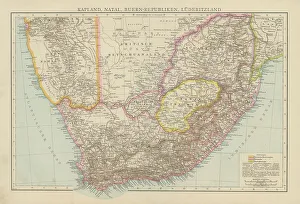
South Africa is a large and diverse country, with many different landscapes. Maps of South Africa are essential for navigating the country and understanding its geography. Maps of South Africa typically include physical features such as rivers, mountains, deserts, and coastlines. They also show major cities and towns, roads, railways, airports, national parks and other points of interest, and are be used to plan trips or explore new areas in the country and can also help visitors find their way around unfamiliar places or get an overview of the entire region at once. With so much to see in South Africa, they can an invaluable tool for discovering all it has to offer.
+

Our beautiful pictures are available as Framed Prints, Photos, Wall Art and Photo Gifts

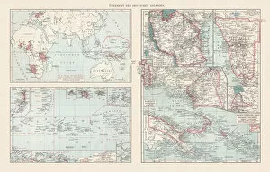
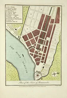
The Maps of South Africa collection from Media Storehouse is a stunning assortment of wall art and framed prints that showcase the diverse geography, history, and culture of South Africa. Our collection features an array of maps dating back to the 17th century, including antique maps depicting the Cape Colony and Natal region. Our collection also includes contemporary topographical maps that highlight the country's natural wonders such as Kruger National Park and Table Mountain. Each print in our collection is carefully crafted using high-quality materials to ensure longevity and durability. These prints are perfect for adding a touch of elegance to any room or office space while providing a glimpse into South Africa's rich history. Whether you're looking for a unique gift or simply want to add some character to your home decor, the Maps of South Africa collection from Media Storehouse offers something for everyone. With its beautiful designs and exceptional quality, our collection is sure to impress anyone who appreciates fine artistry.
+

What are Maps of South Africa Africa art prints?

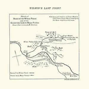
Maps of South Africa art prints are beautiful and informative pieces of artwork that showcase the geography, topography, and landmarks of South Africa. These maps can be used for educational purposes or as decorative pieces in homes, offices, or public spaces. They come in a variety of styles and sizes to suit different tastes and preferences. Some Maps of South Africa art prints feature detailed illustrations that highlight the country's diverse flora and fauna, while others focus on its major cities, highways, and tourist attractions. Some also include historical information about the country's past struggles with apartheid. These art prints are created using high-quality printing techniques that ensure their longevity and vibrancy over time. They make great gifts for anyone who loves travel or has an interest in African culture. Whether you're looking to decorate your home or office space with a unique piece of artwork or want to give a thoughtful gift to someone special, Maps of South Africa art prints are an excellent choice.
+

What Maps of South Africa Africa art prints can I buy from Media Storehouse?

We offer a wide range of South Africa art prints that showcase the beauty and diversity of this stunning country. From detailed maps highlighting its various regions, cities and landmarks to breathtaking landscape photographs capturing its natural wonders, there is something for everyone. You can choose from vintage-style maps that evoke a sense of nostalgia or contemporary designs that reflect modern-day South Africa. Some popular options include maps featuring Cape Town, Johannesburg, Durban and Pretoria as well as prints showcasing iconic attractions such as Table Mountain, Kruger National Park and the Garden Route. Whether you are looking to decorate your home or office with unique wall art or searching for a special gift for someone who loves South Africa, we have an extensive collection of high-quality prints available in different sizes and formats to suit your needs.
+

How do I buy Maps of South Africa Africa art prints?

To buy maps of South Africa and African art prints from Media Storehouse, you can browse our extensive collection online. We offer a wide range of options to choose from, including vintage maps, contemporary designs, and artwork inspired by the natural beauty of Africa. Once you have found the print that you like, simply add it to your cart and proceed to checkout. You will need to provide your shipping information and payment details at this stage. We offer high-quality prints on a variety of materials such as canvas or paper. You can also select different sizes depending on your preferences. If you are looking for something specific but cannot find it in their collection, they may be able to source it for you through their network of photographers and artists. Buying maps of South Africa and African art prints from Media Storehouse is easy and convenient with plenty of options available to suit all tastes.
+

How much do Maps of South Africa Africa art prints cost?

We offer a wide range of Maps of South Africa art prints that vary in price depending on the size and type of print. Our collection includes vintage maps, modern designs, and detailed topographical maps. We understand that our customers have different preferences when it comes to artwork, which is why we provide various options to choose from. Our Maps of South Africa art prints are available in different sizes ranging from small to large formats. Additionally, you can select your preferred print type such as canvas or framed prints. Each option has its unique features and benefits. We take pride in providing high-quality products at affordable prices without compromising on quality. Our team ensures that every order is carefully packaged for safe delivery to your doorstep. The cost of our Maps of South Africa art prints varies based on several factors such as size and print type but rest assured that we offer competitive pricing for all our products.
+

How will my Maps of South Africa Africa art prints be delivered to me?

We take great care in ensuring that your Maps of South Africa art prints are delivered to you safely and securely. We use high-quality packaging materials to protect your artwork during transit, including sturdy cardboard tubes for rolled prints and flat boxes for framed prints. All our deliveries are fulfilled by trusted courier partners who provide a reliable service across the globe. You will receive a tracking number once your order has been dispatched so that you can monitor its progress and ensure someone is available to sign for it upon delivery. We understand how important it is for your artwork to arrive in perfect condition, which is why we offer a no-quibble guarantee on all our products. If there are any issues with your order, please don't hesitate to get in touch with us and we'll do everything we can to put things right.