
Maps Collection
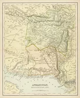
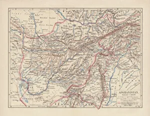
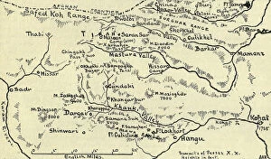
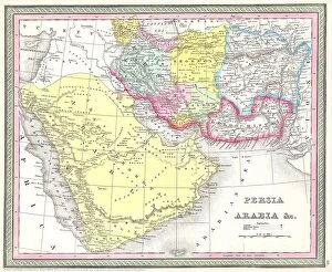
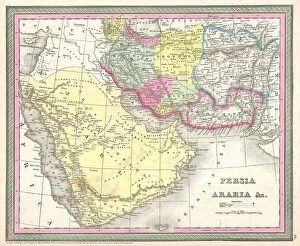
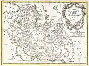
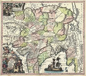
Afghanistan is a landlocked country located in Central and South Asia and has a long and complex history
Choose a picture from our Maps Collection for your Wall Art and Photo Gifts
106 items


All Professionally Made to Order for Quick Shipping
-
Maps Collection
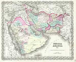
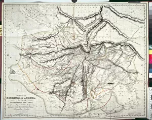
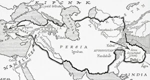
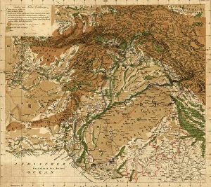
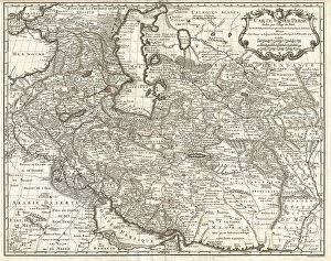
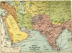
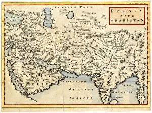
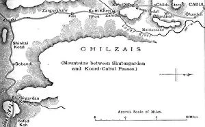
Afghanistan is a landlocked country located in Central and South Asia and has a long and complex history, with many different ethnic groups living within its borders. The country is home to some of the world’s most rugged terrain, including mountains, deserts, and plateaus. Maps of Afghanistan Asia provide an overview of the region’s geography and political divisions. They show major cities such as Kabul and Kandahar, as well as rivers, lakes, mountain ranges, deserts, valleys, roads and other features. It also provide information about the population distribution in Afghanistan; for example they can show which areas are more heavily populated than others. In addition to being useful for travelers or those interested in learning more about this fascinating region of the world maps of Afghanistan Asia can also be used by researchers studying topics such as climate change or migration patterns.
+
Our beautiful pictures are available as Framed Prints, Photos, Wall Art and Photo Gifts
Media Storehouse offers a collection of Maps of Afghanistan Asia, which includes wall art and framed prints that showcase the geography and history of this region. Our collection features maps from different periods, including ancient times to modern-day Afghanistan. These maps provide insight into the country's political boundaries, topography, natural resources, and cultural heritage. The Maps of Afghanistan Asia collection is an excellent resource for historians, geographers, students, or anyone interested in learning about the region's rich history. The detailed illustrations on these maps offer a glimpse into how people lived in this area throughout time. With our high-quality printing technology and materials used for framing prints, customers can be assured that they are receiving a product that will last for years to come. Our collection is perfect for those looking to add some educational yet aesthetically pleasing decor to their home or office space. Our Maps of Afghanistan Asia collection provides an opportunity to explore the fascinating history and geography of one of Central Asia's most intriguing regions through beautiful artwork.
+
What are Maps of Afghanistan Asia art prints?
Maps of Afghanistan Asia art prints are high-quality reproductions of maps that depict the geography, topography, and political boundaries of Afghanistan and its surrounding regions in Asia. These prints are created using advanced printing technology to ensure that they accurately capture the intricate details and nuances of the original maps. These art prints are not only visually stunning but also serve as valuable educational tools for students, historians, geographers, and anyone interested in learning more about this fascinating region. They can be used to study historical events such as wars or migrations, track changes in borders over time or explore natural features like mountain ranges or rivers. Maps of Afghanistan Asia art prints come in a variety of sizes and styles to suit any decor style. They make great additions to home offices, classrooms, libraries or any space where an appreciation for history and culture is valued. Whether you're looking to decorate your walls with beautiful artwork or expand your knowledge about this important part of the world - Maps of Afghanistan Asia art prints have got you covered.
+
What Maps of Afghanistan Asia art prints can I buy from Media Storehouse?
We offer a wide range of Maps of Afghanistan Asia art prints that are perfect for those who have an interest in geography, history, or culture. These maps showcase the intricate details and features of Afghanistan's landscape and its surrounding regions. One popular option is the antique map of Central Asia from 1899, which displays the various countries and territories in the region during that time period. Another great choice is a contemporary satellite image map that highlights Afghanistan's mountain ranges, rivers, cities, and borders. Additionally, Media Storehouse also offers detailed topographical maps that provide a closer look at specific areas within Afghanistan. These maps include information on elevation levels, landmarks, and other geographical features. Whether you're looking to decorate your home or office space with unique artwork or simply want to expand your knowledge about this fascinating country in Asia, we have plenty of Maps of Afghanistan art prints to choose from.
+
How do I buy Maps of Afghanistan Asia art prints?
To buy Maps of Afghanistan Asia art prints from Media Storehouse, you can browse our extensive collection of maps and select the one that best suits your needs. Once you have found the map you want to purchase, simply add it to your cart and proceed to checkout. During the checkout process, you will be prompted to enter your shipping information and payment details. We offer a variety of payment options including credit card, PayPal, and Amazon Pay. We also offer international shipping for customers outside of the UK. Maps of Afghanistan Asia art prints are available in a range of sizes and finishes such as canvas or framed prints. You can choose the size and finish that works best for your space or gift-giving needs. Buying Maps of Afghanistan Asia art prints from Media Storehouse is a simple process that allows you to easily find and purchase high-quality artwork online.
+
How much do Maps of Afghanistan Asia art prints cost?
We offer a wide range of Maps of Afghanistan Asia art prints at varying prices. Our collection includes both vintage and modern maps that showcase the intricate details of Afghanistan's geography and topography. The cost of our Maps of Afghanistan Asia art prints depends on several factors such as the size, material, and framing options you choose. We have different sizes available to suit your preferences, from small to large formats. Our high-quality paper prints are affordable yet durable enough to last for years without fading or losing their vibrancy. If you prefer a more premium look, we also offer canvas prints that add texture and depth to your wall decor. Whatever your budget or style preference may be, we have something for everyone in our collection of Maps of Afghanistan Asia art prints.
+
How will my Maps of Afghanistan Asia art prints be delivered to me?
Your Maps of Afghanistan Asia art prints will be delivered to you through a reliable and secure delivery service. The prints are carefully packaged to ensure their safe arrival at your doorstep. Depending on your location, the delivery may take a few days or longer, but rest assured that we work with trusted shipping partners who strive to deliver your order as quickly as possible. We understand how important it is for our customers to receive their orders in pristine condition, which is why we take great care when packaging and delivering each item. You can expect your Maps of Afghanistan Asia art prints to arrive in excellent condition, ready for framing or display. We pride ourselves on providing exceptional customer service and high-quality products. We want you to enjoy your purchase from us and have a positive experience throughout the entire process – from ordering online to receiving your package at home.