Canvas Print > Arts > Artists > H > Franz Hogenberg
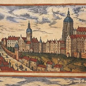
Canvas Print : Map of Rome in 1570 - in "Civitatis Orbis Terranum"


![]()
Canvas Prints From Fine Art Finder
Map of Rome in 1570 - in "Civitatis Orbis Terranum"
GIA4814793 Map of Rome in 1570 - in " Civitatis Orbis Terranum" by Braun and Hogenberg. 1588. by Braun, Georg (1541-1622) and Hogenberg, Franz (1535-90); Private Collection; (add.info.: Map of Rome in 1570 - in " Civitatis Orbis Terranum" by Braun and Hogenberg. 1588.); eGiancarlo Costa; German, out of copyright
Media ID 22290484
© Giancarlo Costa / Bridgeman Images
20"x16" (51x41cm) Canvas Print
Step back in time with our exquisite Canvas Print of the Map of Rome, dating back to 1570. This stunning piece, taken from the renowned "Civitatis Orbis Terranum" collection, is an intricately detailed representation of Rome during the Renaissance era. Created by the masterful hands of Giancarlo Costa, this map is a true work of art, meticulously captured in our high-quality Canvas Print. Bring history into your home and add a touch of timeless elegance to any room.
Delivered stretched and ready to hang our premium quality canvas prints are made from a polyester/cotton blend canvas and stretched over a 1.25" (32mm) kiln dried knot free wood stretcher bar. Packaged in a plastic bag and secured to a cardboard insert for safe transit.
Canvas Prints add colour, depth and texture to any space. Professionally Stretched Canvas over a hidden Wooden Box Frame and Ready to Hang
Estimated Product Size is 50.8cm x 40.6cm (20" x 16")
These are individually made so all sizes are approximate
Artwork printed orientated as per the preview above, with landscape (horizontal) orientation to match the source image.
FEATURES IN THESE COLLECTIONS
> Arts
> Artists
> H
> Franz Hogenberg
> Arts
> Landscape paintings
> Waterfall and river artworks
> River artworks
> Europe
> Germany
> Related Images
> Europe
> Italy
> Lazio
> Rome
> Fine Art Finder
> Artists
> Georg and Hogenberg Franz (1535-90)
> Fine Art Finder
> Artists
> Unknown Artist
EDITORS COMMENTS
This print showcases a detailed map of Rome in the year 1570, taken from the renowned work "Civitatis Orbis Terranum" by Braun and Hogenberg. Created in 1588, this engraving offers a fascinating glimpse into the ancient city's layout during that time period. The map is part of a private collection and was captured by Giancarlo Costa. The intricate details depicted on this map provide an incredible visual representation of Rome's architecture, streets, and landmarks as they stood over four centuries ago. From the winding Tiber River to the majestic buildings that line its banks, every element has been meticulously rendered with precision and accuracy. As one explores this image, it becomes evident how much Rome has evolved throughout history while still retaining its timeless charm. This snapshot transports viewers back in time to experience what life might have been like within these historic walls. Giancarlo Costa's skillful capture brings out the essence of this remarkable piece of cartography. It serves as a testament to both his talent as a photographer and to the enduring significance of historical maps in preserving our collective memory. Whether you are an art enthusiast or simply intrigued by history, this print offers an opportunity to immerse yourself in the rich tapestry of Rome's past.
MADE IN AUSTRALIA
Safe Shipping with 30 Day Money Back Guarantee
FREE PERSONALISATION*
We are proud to offer a range of customisation features including Personalised Captions, Color Filters and Picture Zoom Tools
SECURE PAYMENTS
We happily accept a wide range of payment options so you can pay for the things you need in the way that is most convenient for you
* Options may vary by product and licensing agreement. Zoomed Pictures can be adjusted in the Basket.