Canvas Print > Animals > Mammals > Muridae > Western Mouse
Canvas Print : Map of Western India, 1816 (colour litho)
")
")

![]()
Canvas Prints from Fine Art Finder
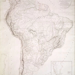
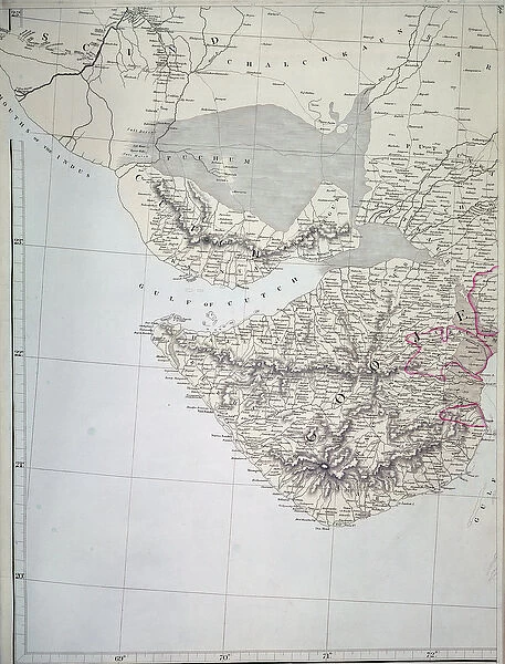
Map of Western India, 1816 (colour litho)
XCF291079 Map of Western India, 1816 (colour litho) by Arrowsmith, Aaron (fl.1810); Private Collection; (add.info.: Aaron Arrowsmith was Hydrographer to HRH the Prince of Wales; ); British, out of copyright
Media ID 22657994
© Bridgeman Images
Bhutan British Empire British India Cutch East India Company Frontier Geographical Mapping Nepal Kathiawar
20"x16" (51x41cm) Canvas Print
Bring history to life with the Media Storehouse Canvas Print of the intricately detailed Map of Western India from 1816. This stunning reproduction, taken from the original colour lithograph by Aaron Arrowsmith, showcases the rich cartographic knowledge of the time. As Hydrographer to HRH the Prince of Wales, Arrowsmith's expertise is evident in this captivating piece. Add a touch of history and sophistication to your space with this beautiful canvas print from Fine Art Finder.
Delivered stretched and ready to hang our premium quality canvas prints are made from a polyester/cotton blend canvas and stretched over a 1.25" (32mm) kiln dried knot free wood stretcher bar. Packaged in a plastic bag and secured to a cardboard insert for safe transit.
Canvas Prints add colour, depth and texture to any space. Professionally Stretched Canvas over a hidden Wooden Box Frame and Ready to Hang
Estimated Product Size is 40.6cm x 50.8cm (16" x 20")
These are individually made so all sizes are approximate
Artwork printed orientated as per the preview above, with portrait (vertical) orientation to match the source image.
FEATURES IN THESE COLLECTIONS
> Animals
> Mammals
> Muridae
> Western Mouse
> Asia
> Bhutan
> Related Images
> Asia
> India
> Related Images
> Asia
> Nepal
> Related Images
> Europe
> United Kingdom
> Wales
> Maps
> Europe
> United Kingdom
> Wales
> Posters
> Europe
> United Kingdom
> Wales
> Related Images
> Fine Art Finder
> Artists
> Aaron Arrowsmith
> Fine Art Finder
> Life Of Christ
EDITORS COMMENTS
This print showcases a remarkable piece of cartography, the "Map of Western India, 1816" by Aaron Arrowsmith. With its vibrant colors and intricate details, this lithograph offers a glimpse into the geographical landscape of British India during the early 19th century. As one gazes upon this historical map, they are transported back in time to an era when colonial powers were expanding their territories and borders were constantly shifting. The map highlights various regions such as Cutch, Nepal, Scind, Bhutan, and Kathiawar among others. It serves as a testament to the extensive mapping efforts undertaken by Arrowsmith under his role as Hydrographer to HRH the Prince of Wales. Every line and contour on this map tells a story of exploration and discovery. From Puchum to Gooje, Puttunwa to Chalchkaun, Jutwaur to Kaunta - each name represents a place with its own unique history within the vast expanse of Western India. This print not only captures an important moment in cartographic history but also invites us to reflect on the impact that colonialism had on these lands. It reminds us that maps have always been powerful tools for understanding our world while simultaneously shaping it. Displayed proudly in any collection or space dedicated to geography enthusiasts or history buffs alike; this stunning lithograph is sure to spark conversations about both past and present boundaries that define our global landscape.
MADE IN AUSTRALIA
Safe Shipping with 30 Day Money Back Guarantee
FREE PERSONALISATION*
We are proud to offer a range of customisation features including Personalised Captions, Color Filters and Picture Zoom Tools
SECURE PAYMENTS
We happily accept a wide range of payment options so you can pay for the things you need in the way that is most convenient for you
* Options may vary by product and licensing agreement. Zoomed Pictures can be adjusted in the Cart.