Canvas Print > Historic > Battles > Battle of Gettysburg
Canvas Print : Map of Gettysburg Battles


![]()
Canvas Prints from Fine Art Storehouse
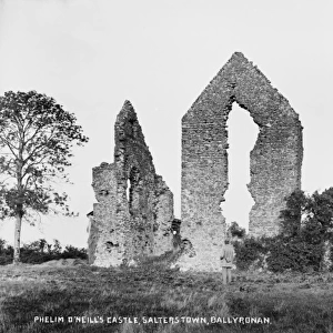
Map of Gettysburg Battles
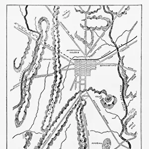
A map of the battles of Gettysburg, 1st to the 3rd July 1863, from an actual survey by an engineer and officer on General Doubledays staff circa 1863. (Photo by Archive Photos/Getty Images)
Unleash your creativity and transform your space into a visual masterpiece!
Archive Photos
Media ID 11927182
© 2010 Getty Images
20"x16" (51x41cm) Canvas Print
Introducing the captivating "Map of Gettysburg Battles" Canvas Print from Media Storehouse, brought to you by Archive Photos at Fine Art Storehouse. This historic piece, captured by an engineer and officer on General Doubleday's staff during the pivotal Battle of Gettysburg in 1863, offers a unique perspective on one of the most significant moments in American history. With intricate details and authenticity that only an original survey can provide, this canvas print transports you back in time. Hang it in your home or office to add a touch of history and character to your space. Experience the past like never before with this exquisite, museum-quality piece from Media Storehouse.
Delivered stretched and ready to hang our premium quality canvas prints are made from a polyester/cotton blend canvas and stretched over a 1.25" (32mm) kiln dried knot free wood stretcher bar. Packaged in a plastic bag and secured to a cardboard insert for safe transit.
Canvas Prints add colour, depth and texture to any space. Professionally Stretched Canvas over a hidden Wooden Box Frame and Ready to Hang
Estimated Product Size is 40.6cm x 50.8cm (16" x 20")
These are individually made so all sizes are approximate
Artwork printed orientated as per the preview above, with portrait (vertical) orientation to match the source image.
FEATURES IN THESE COLLECTIONS
> Historic
> Battles
> Battle of Gettysburg
> Historic
> Battles
> Related Images
> Maps and Charts
> Related Images
> Fine Art Storehouse
> History
> Battles & Wars
> Historcal Battle Maps and Plans
EDITORS COMMENTS
This print showcases a historically significant artifact, the "Map of Gettysburg Battles". With meticulous attention to detail, this map vividly depicts the intense battles that took place from July 1st to July 3rd in 1863. Created by an engineer and officer on General Doubleday's staff during that very period, this map holds immense historical value. The image transports us back in time, allowing us to visualize the strategic movements and key locations where soldiers fought bravely for their respective causes. It serves as a poignant reminder of the sacrifices made by both Union and Confederate forces during one of the bloodiest conflicts in American history. Preserved through years of careful preservation, this print captures every intricate line and symbol etched onto the original map. The level of precision achieved by its creator is truly remarkable – a testament to their expertise as well as their dedication to accurately documenting these pivotal battles. As we gaze upon this piece, we are reminded not only of the events that unfolded at Gettysburg but also of our duty to remember and honor those who fought there. This photograph allows us to connect with history on a deeper level, immersing ourselves in the past while appreciating its significance within our present-day context. With its rich historical background and exquisite craftsmanship, this print from Fine Art Storehouse is sure to captivate any history enthusiast or art lover seeking a tangible connection with America's past.
MADE IN AUSTRALIA
Safe Shipping with 30 Day Money Back Guarantee
FREE PERSONALISATION*
We are proud to offer a range of customisation features including Personalised Captions, Color Filters and Picture Zoom Tools
SECURE PAYMENTS
We happily accept a wide range of payment options so you can pay for the things you need in the way that is most convenient for you
* Options may vary by product and licensing agreement. Zoomed Pictures can be adjusted in the Cart.