Canvas Print > Asia > India > Maps
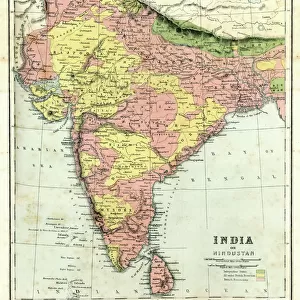
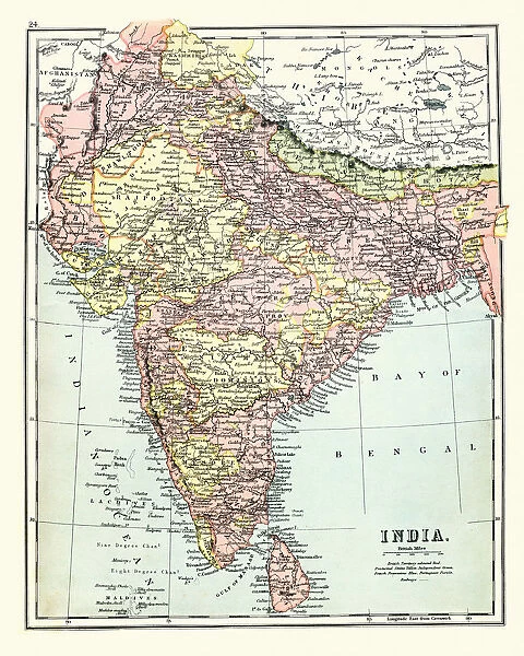
Canvas Print : Antique map of India, 1897, late 19th Century


![]()
Canvas Prints from Fine Art Storehouse
Antique map of India, 1897, late 19th Century
Vintage engraving of a Antique map of India, 1897, late 19th Century
Unleash your creativity and transform your space into a visual masterpiece!
duncan1890
Media ID 18206101
© of Duncan P Walker
20"x16" (51x41cm) Canvas Print
Step back in time with our exquisite Canvas Print of an Antique Map of India from the late 19th Century. This vintage engraving, sourced from the Fine Art Storehouse under the name duncan1890, transports you to a bygone era with intricate details and authentic textures. The rich, vibrant colors and high-quality canvas material bring the historical map to life, making it a stunning addition to any room in your home or office. Relive the charm of the late 1800s and add a touch of history to your space with this beautiful and unique piece of art.
Delivered stretched and ready to hang our premium quality canvas prints are made from a polyester/cotton blend canvas and stretched over a 1.25" (32mm) kiln dried knot free wood stretcher bar. Packaged in a plastic bag and secured to a cardboard insert for safe transit.
Canvas Prints add colour, depth and texture to any space. Professionally Stretched Canvas over a hidden Wooden Box Frame and Ready to Hang
Estimated Product Size is 40.6cm x 50.8cm (16" x 20")
These are individually made so all sizes are approximate
Artwork printed orientated as per the preview above, with portrait (vertical) orientation to match the source image.
FEATURES IN THESE COLLECTIONS
> Asia
> India
> Related Images
> Maps and Charts
> India
> Maps and Charts
> Related Images
> Fine Art Storehouse
> Map
> Historical Maps
EDITORS COMMENTS
This print showcases an exquisite antique map of India, dating back to the late 19th century. Crafted with meticulous detail and precision, this vintage engraving from 1897 offers a fascinating glimpse into the geographical landscape of one of the world's most diverse and culturally rich countries. The map itself is a true work of art, featuring intricate cartographic elements that beautifully depict the various regions, cities, rivers, and mountain ranges that make up India. Each line and contour tells a story of exploration and discovery during a time when maps were not just navigational tools but also cherished pieces of historical documentation. With its sepia-toned hues and delicate textures, this print transports us back in time to an era where hand-drawn maps were highly valued for their accuracy and aesthetic appeal. It serves as a reminder of how far we have come in terms of technological advancements while honoring the craftsmanship that went into creating such masterpieces. Whether you are an avid collector or simply appreciate the beauty found in antiquity, this stunning piece will undoubtedly add sophistication and intrigue to any space it graces. Let yourself be transported through history as you explore every inch of this remarkable antique map - a testament to both India's rich heritage and human curiosity.
MADE IN AUSTRALIA
Safe Shipping with 30 Day Money Back Guarantee
FREE PERSONALISATION*
We are proud to offer a range of customisation features including Personalised Captions, Color Filters and Picture Zoom Tools
SECURE PAYMENTS
We happily accept a wide range of payment options so you can pay for the things you need in the way that is most convenient for you
* Options may vary by product and licensing agreement. Zoomed Pictures can be adjusted in the Cart.