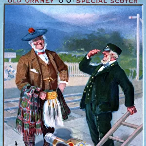
Canvas Print > Europe > United Kingdom > Scotland > Orkney
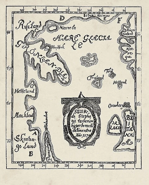
Canvas Print : Map of America Greenland Ireland and Great Britain 1570 by Sigur Stephanius


![]()
Canvas Prints from Fine Art Storehouse
Map of America Greenland Ireland and Great Britain 1570 by Sigur Stephanius
Map of America Greenland Ireland and Great Britain 1570 by Sigur Stephanius
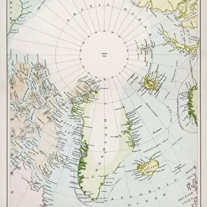
1570 North Atlantic map from the Icelandic geographer Sigurd Stephanius, showing part of western Norway ( Norvegia ), Britain ( Britannia ), Ireland ( Ir Land ), Orkney Islands ( Orcades ), Shetland Islands ( Hetland ), Faroe ( Fero ), Iceland, and Greenland ( Gronlandia ). On the map, Helluland, Markland, Skraeling's Land, and the promontory of Vineland are shown as part of Greenland.
Original edition from my own archives
Source : America 1892
Unleash your creativity and transform your space into a visual masterpiece!
Grafissimo
Media ID 31922059
© Ralf Hettler
20"x16" (51x41cm) Canvas Print
Discover history with our exquisite Canvas Print of the 1570 Map of America, Greenland, Ireland, and Great Britain by Sigurd Stephanius. This rare and intriguing map, published by Grafissimo in the Fine Art Storehouse collection, showcases the North Atlantic region as it was known during the Renaissance period. The detailed depiction of Norway, Greenland, Ireland, and Great Britain is a captivating glimpse into the past, perfect for history enthusiasts, cartography aficionados, or anyone seeking to add a touch of vintage charm to their home or office decor. Bring the rich history of the Old World into your space with this stunning, museum-quality Canvas Print.
Delivered stretched and ready to hang our premium quality canvas prints are made from a polyester/cotton blend canvas and stretched over a 1.25" (32mm) kiln dried knot free wood stretcher bar. Packaged in a plastic bag and secured to a cardboard insert for safe transit.
Canvas Prints add colour, depth and texture to any space. Professionally Stretched Canvas over a hidden Wooden Box Frame and Ready to Hang
Estimated Product Size is 40.6cm x 50.8cm (16" x 20")
These are individually made so all sizes are approximate
Artwork printed orientated as per the preview above, with portrait (vertical) orientation to match the source image.
FEATURES IN THESE COLLECTIONS
> Animals
> Mammals
> Muridae
> Western Mouse
> Europe
> France
> Canton
> Landes
> Europe
> Iceland
> Related Images
> Europe
> Norway
> Related Images
> Europe
> Republic of Ireland
> Maps
> Europe
> United Kingdom
> Scotland
> Orkney
> Fine Art Storehouse
> Map
> Historical Maps
EDITORS COMMENTS
This print showcases the "Map of America Greenland Ireland and Great Britain 1570" by Sigur Stephanius, a renowned Icelandic geographer. Dating back to 1570, this North Atlantic map provides a fascinating glimpse into the geographical knowledge of that era. The intricate details on this map are truly remarkable. It depicts part of western Norway as Norvegia, while highlighting prominent regions such as Britain (Britannia), Ireland (Ir Land), Orkney Islands (Orcades), Shetland Islands (Hetland), Faroe (Fero), Iceland, and Greenland (Gronlandia). Notably, Helluland, Markland, Skraeling's Land, and Vineland's promontory are also shown as part of Greenland. As an original edition from the personal archives of Grafissimo Fine Art Storehouse, this print holds immense historical value. It offers viewers a chance to appreciate the cartographic skills employed during that time period and gain insights into how these lands were perceived centuries ago. Whether you're an avid history enthusiast or simply intrigued by ancient maps, this stunning artwork is sure to captivate your imagination. Let it transport you back in time to an era when exploration was at its peak and discover the rich tapestry woven across America, Greenland, Ireland, and Great Britain in 1570.
MADE IN AUSTRALIA
Safe Shipping with 30 Day Money Back Guarantee
FREE PERSONALISATION*
We are proud to offer a range of customisation features including Personalised Captions, Color Filters and Picture Zoom Tools
SECURE PAYMENTS
We happily accept a wide range of payment options so you can pay for the things you need in the way that is most convenient for you
* Options may vary by product and licensing agreement. Zoomed Pictures can be adjusted in the Cart.