Canvas Print > North America > United States of America > New York > New York > Maps
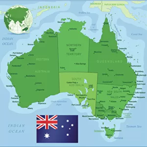
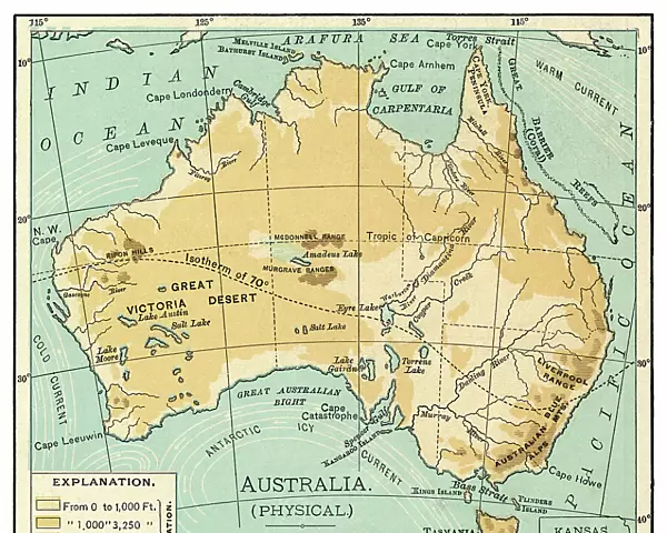
Canvas Print : Map of Australia 1895


![]()
Canvas Prints from Fine Art Storehouse
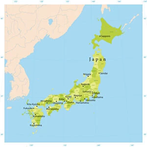
Map of Australia 1895
The Rand-McNally Grammar School Geography 1895 - Chicago & New York
Unleash your creativity and transform your space into a visual masterpiece!
THEPALMER
Media ID 14824643
© This content is subject to copyright
Australasia Australia Indonesia Malaysia New Zealand Oceania Pacific Papua Solomon Tasmania
20"x16" (51x41cm) Canvas Print
Discover the historical charm of yesteryears with our Media Storehouse Canvas Print of the Map of Australia 1895 by THEPALMER from the Fine Art Storehouse. This captivating piece showcases an intriguing snapshot of geographical knowledge from 1895, as published by Rand-McNally in Chicago and New York. Perfectly replicated onto a high-quality canvas, this Map of Australia print is not just a decorative addition to your space, but a window into the past. Travel back in time and add a touch of vintage elegance to your home or office with this unique and intriguing canvas print.
Delivered stretched and ready to hang our premium quality canvas prints are made from a polyester/cotton blend canvas and stretched over a 1.25" (32mm) kiln dried knot free wood stretcher bar. Packaged in a plastic bag and secured to a cardboard insert for safe transit.
Canvas Prints add colour, depth and texture to any space. Professionally Stretched Canvas over a hidden Wooden Box Frame and Ready to Hang
Estimated Product Size is 50.8cm x 40.6cm (20" x 16")
These are individually made so all sizes are approximate
Artwork printed orientated as per the preview above, with landscape (horizontal) orientation to match the source image.
FEATURES IN THESE COLLECTIONS
> Asia
> Indonesia
> Related Images
> Asia
> Malaysia
> Related Images
> Maps and Charts
> Related Images
> North America
> United States of America
> New York
> New York
> Maps
> North America
> United States of America
> New York
> Related Images
> Oceania
> Australia
> Related Images
> Fine Art Storehouse
> Map
> Historical Maps
EDITORS COMMENTS
This print titled "Map of Australia 1895" takes us on a journey back in time to the late 19th century. The map, sourced from "The Rand-McNally Grammar School Geography 1895 - Chicago & New York" showcases the intricate details and craftsmanship that went into cartography during this era. As we gaze upon this vintage piece, we are transported to an age when exploration and discovery were at their peak. The map encompasses not only the vast continent of Australia but also highlights neighboring regions such as Malaysia, Tasmania, Australasia, Indonesia, New Zealand, Oceania, Pacific Islands including Papua and Solomon. The fine art print by THEPALMER captures every minute detail with precision and elegance. Each contour line and geographical feature is meticulously depicted using rich colors that bring life to the paper. This artwork serves as a testament to both historical accuracy and artistic expression. Beyond its aesthetic appeal lies a deeper appreciation for the significance of maps in shaping our understanding of the world. It reminds us of how boundaries have evolved over time while showcasing Australia's unique position within Oceania. Whether displayed in a classroom or home setting, this print invites viewers to immerse themselves in history while appreciating the beauty found within old-world cartography. THEPALMER's work truly encapsulates the essence of this remarkable period in geography's evolution.
MADE IN AUSTRALIA
Safe Shipping with 30 Day Money Back Guarantee
FREE PERSONALISATION*
We are proud to offer a range of customisation features including Personalised Captions, Color Filters and Picture Zoom Tools
SECURE PAYMENTS
We happily accept a wide range of payment options so you can pay for the things you need in the way that is most convenient for you
* Options may vary by product and licensing agreement. Zoomed Pictures can be adjusted in the Cart.