Canvas Print > Europe > Russia > Maps
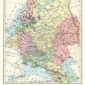
Canvas Print : Map of west russia 1896


![]()
Canvas Prints from Fine Art Storehouse
Map of west russia 1896
Andres Allgemeiner Handatlas - Bielefeld und Leipzig 1896
Unleash your creativity and transform your space into a visual masterpiece!
THEPALMER
Media ID 18356815
20"x16" (51x41cm) Canvas Print
Discover the historical charm of the past with our exquisite Canvas Print of "Map of West Russia 1896" by THEPALMER from our Media Storehouse Fine Art collection. This stunning reproduction is taken from the Andres Allgemeiner Handatlas published in Bielefeld and Leipzig in 1896. Each print is meticulously crafted on high-quality canvas, bringing the intricate details of this vintage map to life. Add a touch of history and sophistication to your home or office decor with this unique and captivating piece.
Delivered stretched and ready to hang our premium quality canvas prints are made from a polyester/cotton blend canvas and stretched over a 1.25" (32mm) kiln dried knot free wood stretcher bar. Packaged in a plastic bag and secured to a cardboard insert for safe transit.
Canvas Prints add colour, depth and texture to any space. Professionally Stretched Canvas over a hidden Wooden Box Frame and Ready to Hang
Estimated Product Size is 50.8cm x 40.6cm (20" x 16")
These are individually made so all sizes are approximate
Artwork printed orientated as per the preview above, with landscape (horizontal) orientation to match the source image.
FEATURES IN THESE COLLECTIONS
> Europe
> Russia
> Related Images
> Maps and Charts
> Related Images
> Fine Art Storehouse
> Map
> Historical Maps
EDITORS COMMENTS
This print showcases a remarkable piece of history, the "Map of West Russia 1896" from Andres Allgemeiner Handatlas. With its intricate details and vintage charm, this print takes us back to a time when cartography was an art form in itself. The map, originally published in Bielefeld und Leipzig in 1896, offers a fascinating glimpse into the geography and boundaries of Western Russia during that era. The careful craftsmanship evident in this print highlights the dedication and precision required to create such comprehensive maps before the advent of modern technology. Every contour line, river system, city name, and border is meticulously depicted with utmost accuracy. This snapshot from Fine Art Storehouse allows us to appreciate not only the historical significance but also the artistic beauty inherent in these old cartographic works. As we gaze upon this stunning reproduction by THEPALMER, we are transported back to a time when exploration and discovery were at their peak. It serves as a reminder of how far our understanding of geography has come since then while honoring those who dedicated their lives to mapping out our world. Whether you're an avid collector or simply captivated by history's allure, this print is sure to be a cherished addition to any space. Its timeless appeal makes it perfect for both educational environments seeking visual aids or individuals looking for unique decor pieces that spark curiosity about our past.
MADE IN AUSTRALIA
Safe Shipping with 30 Day Money Back Guarantee
FREE PERSONALISATION*
We are proud to offer a range of customisation features including Personalised Captions, Color Filters and Picture Zoom Tools
SECURE PAYMENTS
We happily accept a wide range of payment options so you can pay for the things you need in the way that is most convenient for you
* Options may vary by product and licensing agreement. Zoomed Pictures can be adjusted in the Cart.