Canvas Print > Maps and Charts > Americas
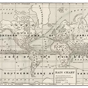
Canvas Print : Map of the world 1889


![]()
Canvas Prints from Fine Art Storehouse
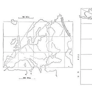
Map of the world 1889
Comprehensive Geography by James Monteith - American Book Company 1882, 1889
Unleash your creativity and transform your space into a visual masterpiece!
THEPALMER
Media ID 18357259
30"x20" (76x51cm) Canvas Print
Discover the captivating allure of history with our Media Storehouse Canvas Print of the 1889 Map of the World by THEPALMER. This exquisite piece, taken from the Comprehensive Geography book published by the American Book Company in 1882, showcases the world as it was known over a century ago. Each detail, from the intricate border designs to the meticulously rendered continents and islands, is brought to life on high-quality canvas, ensuring a stunning addition to any room. Travel back in time and explore the world's rich history with this unique and captivating piece of art.
Delivered stretched and ready to hang our premium quality canvas prints are made from a polyester/cotton blend canvas and stretched over a 1.25" (32mm) kiln dried knot free wood stretcher bar. Packaged in a plastic bag and secured to a cardboard insert for safe transit.
Canvas Prints add colour, depth and texture to any space. Professionally Stretched Canvas over a hidden Wooden Box Frame and Ready to Hang
Estimated Product Size is 76.2cm x 50.8cm (30" x 20")
These are individually made so all sizes are approximate
Artwork printed orientated as per the preview above, with landscape (horizontal) orientation to match the source image.
FEATURES IN THESE COLLECTIONS
> Maps and Charts
> Related Images
> Maps and Charts
> World
> Fine Art Storehouse
> Map
> Historical Maps
EDITORS COMMENTS
In this print titled "Map of the world 1889" we are transported back in time to an era when exploration and discovery were at their peak. The map, originally featured in James Monteith's Comprehensive Geography published by the American Book Company in 1882 and updated in 1889, offers a fascinating glimpse into the global knowledge of that period. The intricate details of this vintage map immediately catch our attention. Delicately drawn coastlines trace the contours of continents, while vibrant colors distinguish different countries and territories. It is evident that cartographers painstakingly crafted this piece with precision and artistry. As we study this historical artifact, we can't help but marvel at how much our understanding of the world has evolved since then. Boundaries have shifted, nations have risen and fallen, yet this snapshot from over a century ago serves as a reminder of humanity's insatiable curiosity about distant lands. "The Map of the World 1889" transports us beyond borders and invites us to embark on a journey through time. It sparks wonderment about past civilizations' perceptions of geography and ignites contemplation about our own place within an ever-changing world. THEPALMER's expert reproduction allows us to appreciate every fine detail captured within this remarkable print. Whether displayed for educational purposes or simply admired for its aesthetic appeal, it undoubtedly serves as both an artistic masterpiece and a valuable historical document.
MADE IN AUSTRALIA
Safe Shipping with 30 Day Money Back Guarantee
FREE PERSONALISATION*
We are proud to offer a range of customisation features including Personalised Captions, Color Filters and Picture Zoom Tools
SECURE PAYMENTS
We happily accept a wide range of payment options so you can pay for the things you need in the way that is most convenient for you
* Options may vary by product and licensing agreement. Zoomed Pictures can be adjusted in the Cart.