Canvas Print > Europe > Germany > Maps
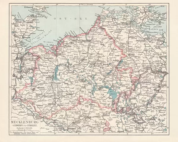
Canvas Print : Topographic map of Mecklenburg, Germany, lithograph, published in 1897


![]()
Canvas Prints from Fine Art Storehouse
Topographic map of Mecklenburg, Germany, lithograph, published in 1897
Topographic map of Mecklenburg in Germany. Lithograph, published in 1897
Unleash your creativity and transform your space into a visual masterpiece!
ZU_09
Media ID 18106713
20"x16" (51x41cm) Canvas Print
Discover the rich history of Mecklenburg, Germany with our stunning Topographic Map Canvas Print from the Media Storehouse collection. This beautiful lithograph, published in 1897 by ZU_09 from Fine Art Storehouse, showcases intricate details of the topography of the region. Bring the past into your present with this unique and captivating piece of art, perfect for adding character to any room in your home or office. Experience the timeless beauty of this historical map in a whole new way with our high-quality canvas print.
Delivered stretched and ready to hang our premium quality canvas prints are made from a polyester/cotton blend canvas and stretched over a 1.25" (32mm) kiln dried knot free wood stretcher bar. Packaged in a plastic bag and secured to a cardboard insert for safe transit.
Canvas Prints add colour, depth and texture to any space. Professionally Stretched Canvas over a hidden Wooden Box Frame and Ready to Hang
Estimated Product Size is 50.8cm x 40.6cm (20" x 16")
These are individually made so all sizes are approximate
Artwork printed orientated as per the preview above, with landscape (horizontal) orientation to match the source image.
FEATURES IN THESE COLLECTIONS
> Europe
> Germany
> Related Images
> Maps and Charts
> Related Images
> Fine Art Storehouse
> Map
> Historical Maps
EDITORS COMMENTS
This lithograph, titled "Topographic map of Mecklenburg, Germany" takes us on a journey back in time to the year 1897. Created by the talented artist ZU_09, this print showcases an intricate and detailed representation of the Mecklenburg region in Germany. The map is meticulously crafted with fine lines and delicate shading, capturing every contour and feature of the landscape. From rolling hills to winding rivers and dense forests, it offers a comprehensive view of this historic German territory. As we delve into this piece, our eyes are drawn to the remarkable precision with which each town, village, and road is depicted. The names are elegantly inscribed beside their respective locations, inviting us to explore further. Beyond its aesthetic appeal lies a wealth of historical information waiting to be discovered. This topographic map not only serves as an artistic masterpiece but also as a valuable resource for researchers or enthusiasts interested in studying Mecklenburg's geography during that era. Whether displayed in a study or admired within an educational setting, this lithograph transports us back over a century ago when cartography was both artistry and science combined. It reminds us of the immense effort invested by artists like ZU_09 who dedicated themselves to accurately documenting our world through their craft. With its timeless beauty and rich historical significance, this print truly captures the essence of Mecklenburg's landscape while offering viewers an opportunity to appreciate both artistry and history intertwined within one extraordinary piece.
MADE IN AUSTRALIA
Safe Shipping with 30 Day Money Back Guarantee
FREE PERSONALISATION*
We are proud to offer a range of customisation features including Personalised Captions, Color Filters and Picture Zoom Tools
SECURE PAYMENTS
We happily accept a wide range of payment options so you can pay for the things you need in the way that is most convenient for you
* Options may vary by product and licensing agreement. Zoomed Pictures can be adjusted in the Cart.