Canvas Print > Arts > Photorealistic artworks > Detailed art pieces > Masterful detailing in art
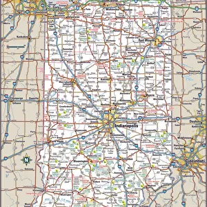
Canvas Print : Indiana Map


![]()
Canvas Prints from Fine Art Storehouse
Indiana Map
A detailed map of Indiana state with cities, roads, major rivers, and lakes plus National Forests. Includes neighboring states and surrounding water
Unleash your creativity and transform your space into a visual masterpiece!
Media ID 15495565
20"x16" (51x41cm) Canvas Print
Discover the beauty of Indiana with our exquisite Canvas Prints from Media Storehouse's Fine Art Storehouse collection. This stunning piece showcases an intricately detailed map of the Hoosier State, featuring cities, major roads, rivers, and lakes. Delve deeper into the geography of Indiana as you explore the borders of neighboring states and the surrounding water. Each Canvas Print is meticulously crafted with premium materials, ensuring vibrant colors and exceptional detail that will bring this work of art to life in your home or office. Elevate your interior décor with the timeless charm of a map and the captivating allure of Indiana's landscape.
Delivered stretched and ready to hang our premium quality canvas prints are made from a polyester/cotton blend canvas and stretched over a 1.25" (32mm) kiln dried knot free wood stretcher bar. Packaged in a plastic bag and secured to a cardboard insert for safe transit.
Canvas Prints add colour, depth and texture to any space. Professionally Stretched Canvas over a hidden Wooden Box Frame and Ready to Hang
Estimated Product Size is 40.6cm x 50.8cm (16" x 20")
These are individually made so all sizes are approximate
Artwork printed orientated as per the preview above, with portrait (vertical) orientation to match the source image.
FEATURES IN THESE COLLECTIONS
> Animals
> Mammals
> Muridae
> Water Mouse
> Arts
> Landscape paintings
> Forest and woodland scenes
> Forest artwork
> Arts
> Landscape paintings
> Waterfall and river artworks
> River artworks
> Arts
> Photorealistic artworks
> Detailed art pieces
> Masterful detailing in art
> Maps and Charts
> Related Images
> Fine Art Storehouse
> Map
> Reference Maps
EDITORS COMMENTS
This stunning print showcases the intricate details of Indiana's geography, providing a comprehensive map of the state. From its bustling cities to winding roads, major rivers, and serene lakes, this artwork captures the essence of Indiana's diverse landscape. The inclusion of National Forests highlights the state's commitment to preserving its natural beauty. Not limited to just depicting Indiana alone, this map also encompasses neighboring states and surrounding water bodies. It serves as a visual gateway into understanding how Indiana fits within the larger regional context. The artist behind this masterpiece has skillfully captured every minute detail with precision and clarity. Each city is marked with accuracy, allowing viewers to trace their fingers along familiar routes or discover new destinations within the state. Whether you are an avid traveler planning your next road trip through Indiana or simply have an appreciation for cartography and artistry, this print from Fine Art Storehouse is sure to captivate your imagination. Hang it in your home or office space as a conversation starter or use it as a reference tool for educational purposes
MADE IN AUSTRALIA
Safe Shipping with 30 Day Money Back Guarantee
FREE PERSONALISATION*
We are proud to offer a range of customisation features including Personalised Captions, Color Filters and Picture Zoom Tools
SECURE PAYMENTS
We happily accept a wide range of payment options so you can pay for the things you need in the way that is most convenient for you
* Options may vary by product and licensing agreement. Zoomed Pictures can be adjusted in the Cart.