Canvas Print > Fine Art Storehouse > Map
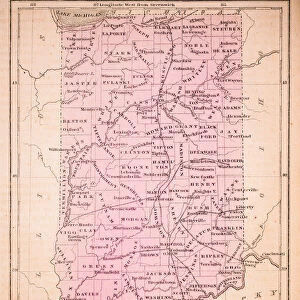
Canvas Print : Ohio Indiana Illinois map 1867


![]()
Canvas Prints from Fine Art Storehouse
Ohio Indiana Illinois map 1867
Mitchellas Modern Atlas - Published by E.H. Butler and Co - Philadelphia 1867
Unleash your creativity and transform your space into a visual masterpiece!
THEPALMER
Media ID 13609223
© This content is subject to copyright
Illinois Indiana Iowa Kentucky Michigan Missouri Ohio
30"x20" (76x51cm) Canvas Print
Step back in time with our exquisite Canvas Print of the "Ohio Indiana Illinois map 1867" by THEPALMER from the Media Storehouse Fine Art Storehouse collection. This captivating vintage map, taken from Mitchell's Modern Atlas published by E.H. Butler and Co in Philadelphia, 1867, is a stunning addition to any home or office décor. The intricate details and rich colors of this historical map come alive on high-quality canvas, making it a unique and conversation-starting piece. Relive history with this beautiful and authentic reproduction, sure to inspire wonder and curiosity in all who see it.
Delivered stretched and ready to hang our premium quality canvas prints are made from a polyester/cotton blend canvas and stretched over a 1.25" (32mm) kiln dried knot free wood stretcher bar. Packaged in a plastic bag and secured to a cardboard insert for safe transit.
Canvas Prints add colour, depth and texture to any space. Professionally Stretched Canvas over a hidden Wooden Box Frame and Ready to Hang
Estimated Product Size is 76.2cm x 50.8cm (30" x 20")
These are individually made so all sizes are approximate
Artwork printed orientated as per the preview above, with landscape (horizontal) orientation to match the source image.
FEATURES IN THESE COLLECTIONS
> Fine Art Storehouse
> Map
> Historical Maps
> Fine Art Storehouse
> Map
> USA Maps
EDITORS COMMENTS
This print showcases a remarkable piece of history - the Ohio Indiana Illinois map from 1867. Published by E. H. Butler and Co in Philadelphia, this vintage map offers a fascinating glimpse into the past. The intricate details of this lithograph are truly impressive, showcasing the artistry and craftsmanship of the time. As we gaze upon this antique illustration, we are transported back to an era when cartography was painstakingly created through engraving and etching techniques. The physical geography of these states - Illinois, Indiana, Iowa, Kentucky, Michigan, Missouri, and Ohio - is beautifully depicted with precision and accuracy. The horizontal composition allows us to explore every corner of this historical treasure. Each line represents a road traveled long ago; each contour reveals natural features that have shaped these landscapes for centuries. While admiring this old map's charm and elegance, one cannot help but marvel at how much has changed since its creation over 150 years ago. It serves as a reminder of our ever-evolving world while also preserving the rich heritage embedded within these regions. "TheOhio Indiana Illinois map 1867" by THEPALMER is more than just an artwork; it is a portal to another time. This print invites us to reflect on our roots while appreciating the beauty found in both artistry and geography alike.
MADE IN AUSTRALIA
Safe Shipping with 30 Day Money Back Guarantee
FREE PERSONALISATION*
We are proud to offer a range of customisation features including Personalised Captions, Color Filters and Picture Zoom Tools
SECURE PAYMENTS
We happily accept a wide range of payment options so you can pay for the things you need in the way that is most convenient for you
* Options may vary by product and licensing agreement. Zoomed Pictures can be adjusted in the Cart.