Canvas Print > Fine Art Storehouse > Photo Libraries > Dorling Kindersley Prints
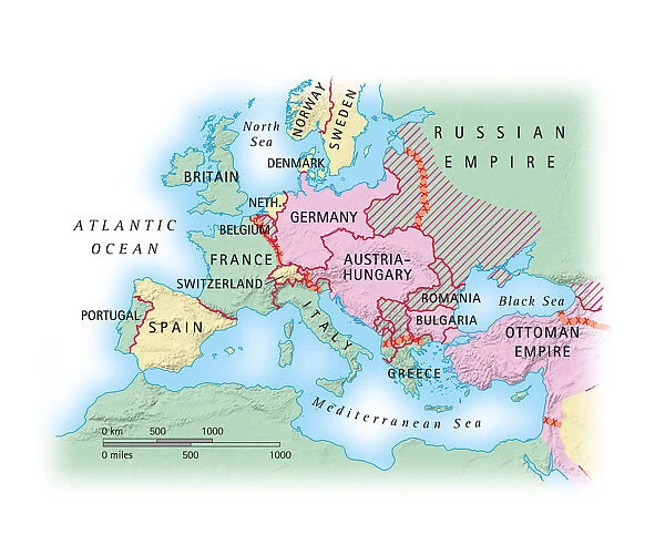
Canvas Print : Digital illustration of map of Europe during World War I
![]()

Canvas Prints from Fine Art Storehouse
Digital illustration of map of Europe during World War I
Unleash your creativity and transform your space into a visual masterpiece!
Dorling Kindersley
Media ID 13541073
© This content is subject to copyright
Scale Western Script World War I World War One Digitally Generated Digitally Generated Image
20"x16" (51x41cm) Canvas Print
Add history to your home decor with the Media Storehouse Canvas Print featuring a digitally illustrated map of Europe during World War I from Dorling Kindersley's Fine Art Storehouse. This captivating piece transports you back in time, meticulously detailing the political landscape of Europe during a pivotal period. The high-quality canvas print brings vibrant colors and intricate details to life, making it a stunning conversation starter in any room. Relive history with this unique and beautiful addition to your collection.
Delivered stretched and ready to hang our premium quality canvas prints are made from a polyester/cotton blend canvas and stretched over a 1.25" (32mm) kiln dried knot free wood stretcher bar. Packaged in a plastic bag and secured to a cardboard insert for safe transit.
Canvas Prints add colour, depth and texture to any space. Professionally Stretched Canvas over a hidden Wooden Box Frame and Ready to Hang
Estimated Product Size is 50.8cm x 40.6cm (20" x 16")
These are individually made so all sizes are approximate
Artwork printed orientated as per the preview above, with landscape (horizontal) orientation to match the source image.
FEATURES IN THESE COLLECTIONS
> Fine Art Storehouse
> History
> Battles & Wars
> World War I (1914-1918)
> Fine Art Storehouse
> Photo Libraries
> Dorling Kindersley Prints
EDITORS COMMENTS
This digital illustration transports us back in time to the tumultuous era of World War I. With a white background that enhances its clarity, this map of Europe during the Great War is meticulously crafted by Dorling Kindersley. The artist's attention to detail is evident as every border, city, and geographical feature is intricately depicted. The vibrant colors used in this digitally generated image bring life to an otherwise dark period in history. Shades of green represent the vast empires that once dominated Europe, while splashes of red symbolize the bloodshed and conflict that engulfed the continent during those years. As we study this horizontal map, it becomes apparent how borders were redrawn and nations were reshaped amidst the chaos of war. This studio shot allows us to examine each region with precision and appreciate the scale at which these historical events unfolded. Although devoid of people, this illustration speaks volumes about human struggle and resilience. It serves as a reminder of our shared past and encourages reflection on how far we have come since then. Dorling Kindersley's masterful cartography skills shine through in this artwork from Fine Art Storehouse. Through their talent for merging artistry with historical accuracy, they have created a visually stunning representation of World War I's impact on Europe – an invaluable addition to any collection or educational resource dedicated to understanding our complex world history.
MADE IN AUSTRALIA
Safe Shipping with 30 Day Money Back Guarantee
FREE PERSONALISATION*
We are proud to offer a range of customisation features including Personalised Captions, Color Filters and Picture Zoom Tools
SECURE PAYMENTS
We happily accept a wide range of payment options so you can pay for the things you need in the way that is most convenient for you
* Options may vary by product and licensing agreement. Zoomed Pictures can be adjusted in the Cart.


