Canvas Print > Asia > Saudi Arabia > Maps
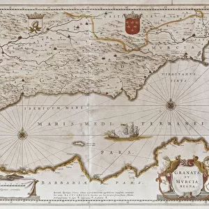
Canvas Print : WORLD WAR I: MIDDLE EAST. Map, 1919, of the Middle East and the lines of battle


![]()
Canvas Prints from Granger
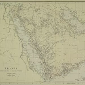
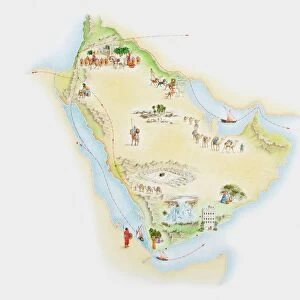
WORLD WAR I: MIDDLE EAST. Map, 1919, of the Middle East and the lines of battle
WORLD WAR I: MIDDLE EAST.
Map, 1919, of the Middle East and the lines of battle during World War I
Granger holds millions of images spanning more than 25,000 years of world history, from before the Stone Age to the dawn of the Space Age
Media ID 12405884
1914 1915 1916 1917 1918 Battle Middle East Middle Eastern Persia Red Sea Saudi Arabia Turkey Turkish World War I Arabian Peninsula Persian Gulf
20"x16" (51x41cm) Canvas Print
Step back in time with our WORLD WAR I: MIDDLE EAST Canvas Print from Media Storehouse and Granger Art on Demand. This captivating map, created in 1919, showcases the Middle East during the pivotal years of World War I. The intricate lines of battle are brought to life in vibrant detail, making this an essential addition to any history or military enthusiast's collection. Our high-quality canvas prints are meticulously crafted to bring out the rich colors and intricate details of this historical artwork, ensuring a stunning display in your home or office.
Delivered stretched and ready to hang our premium quality canvas prints are made from a polyester/cotton blend canvas and stretched over a 1.25" (32mm) kiln dried knot free wood stretcher bar. Packaged in a plastic bag and secured to a cardboard insert for safe transit.
Canvas Prints add colour, depth and texture to any space. Professionally Stretched Canvas over a hidden Wooden Box Frame and Ready to Hang
Estimated Product Size is 40.6cm x 50.8cm (16" x 20")
These are individually made so all sizes are approximate
Artwork printed orientated as per the preview above, with portrait (vertical) orientation to match the source image.
FEATURES IN THESE COLLECTIONS
> Asia
> Saudi Arabia
> Maps
> Asia
> Saudi Arabia
> Related Images
> Asia
> Turkey
> Related Images
> Historic
> Battles
> Related Images
> Historic
> World War I and II
> World War I
> Maps and Charts
> Related Images
> Maps and Charts
> World
> Granger Art on Demand
> 20th Century Wars
EDITORS COMMENTS
This print titled "WORLD WAR I: MIDDLE EAST. Map, 1919, of the Middle East and the lines of battle" takes us back in time to one of the most significant periods in history. The map showcases the intricate web of conflicts that unfolded during World War I across the Middle East. The image transports us to a world engulfed by war, where nations clashed and borders shifted. The lines etched on this map represent not only physical boundaries but also symbolize the struggles and sacrifices made by countless individuals. As we delve into this historical artifact, we witness how power dynamics played out between various countries such as Turkey, Saudi Arabia, and Persia (modern-day Iran). The Arabian Peninsula emerges as a focal point with its strategic position between the Persian Gulf and Red Sea. Beyond its geographical significance, this map serves as a testament to human resilience amidst chaos. It reminds us that even amid destruction and turmoil, people strive for stability and peace. While appreciating this photograph print from Granger Art on Demand, it is important to acknowledge its historical value rather than focusing solely on commercial use. Let's reflect upon those who fought bravely during World War I in an effort to shape our present reality while honoring their memory through understanding our shared past.
MADE IN AUSTRALIA
Safe Shipping with 30 Day Money Back Guarantee
FREE PERSONALISATION*
We are proud to offer a range of customisation features including Personalised Captions, Color Filters and Picture Zoom Tools
SECURE PAYMENTS
We happily accept a wide range of payment options so you can pay for the things you need in the way that is most convenient for you
* Options may vary by product and licensing agreement. Zoomed Pictures can be adjusted in the Cart.