Canvas Print > Granger Art on Demand > American History
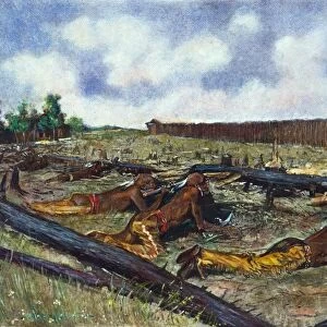
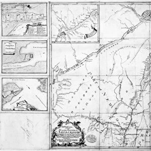
Canvas Print : FRENCH & INDIAN WAR: MAP. Map of the scenes of operation and major campaigns during the French


![]()
Canvas Prints from Granger
FRENCH & INDIAN WAR: MAP. Map of the scenes of operation and major campaigns during the French
FRENCH & INDIAN WAR: MAP.
Map of the scenes of operation and major campaigns during the French and Indian War, 1754-55. American drawing, 19th century
Granger holds millions of images spanning more than 25,000 years of world history, from before the Stone Age to the dawn of the Space Age
Media ID 12225363
1750s American Indian Canada Colony French Indian War Lake Ontario New France New York Pennsylvania United States
20"x16" (51x41cm) Canvas Print
Transport history to your home with our stunning Canvas Prints from Media Storehouse. This captivating map, titled "French & Indian War: Map of the Scenes of Operation and Major Campaigns during the French and Indian War, 1754-55," is an exquisite addition to any decor. Originally an American drawing from the 19th century, now brought to you by Granger Art on Demand, this detailed map showcases the major campaigns and scenes of the French and Indian War. With vibrant colors and sharp details, our Canvas Prints bring the intricacies of this historical artwork to life. Elevate your space with a touch of history and beauty.
Delivered stretched and ready to hang our premium quality canvas prints are made from a polyester/cotton blend canvas and stretched over a 1.25" (32mm) kiln dried knot free wood stretcher bar. Packaged in a plastic bag and secured to a cardboard insert for safe transit.
Canvas Prints add colour, depth and texture to any space. Professionally Stretched Canvas over a hidden Wooden Box Frame and Ready to Hang
Estimated Product Size is 40.6cm x 50.8cm (16" x 20")
These are individually made so all sizes are approximate
Artwork printed orientated as per the preview above, with portrait (vertical) orientation to match the source image.
EDITORS COMMENTS
This print titled "FRENCH & INDIAN WAR: MAP" takes us back to the 1750s, providing a glimpse into the scenes of operation and major campaigns during the French and Indian War. The map, drawn by an American artist in the 19th century, offers a detailed depiction of this significant conflict that shaped America's history. As we examine the intricacies of this artwork, our eyes are immediately drawn to its rich colors and precise cartographic details. The map showcases various locations such as New France (present-day Canada), New York, Pennsylvania, and even Lake Ontario. It highlights not only geographical features but also important rivers that played a crucial role in military strategies during this war. The image invites us to explore further - tracing the routes taken by both French and British forces as they clashed for control over North American territories. We can almost envision soldiers marching through dense forests or engaging in fierce battles along these very paths. Beyond its historical significance, this print is a testament to artistic talent from centuries ago. Its meticulous craftsmanship transports us back in time while reminding us of how conflicts have shaped nations throughout history. Whether you are an avid historian or simply appreciate fine art with a touch of nostalgia, "FRENCH & INDIAN WAR: MAP" is sure to captivate your imagination and spark curiosity about one of America's defining moments.
MADE IN AUSTRALIA
Safe Shipping with 30 Day Money Back Guarantee
FREE PERSONALISATION*
We are proud to offer a range of customisation features including Personalised Captions, Color Filters and Picture Zoom Tools
SECURE PAYMENTS
We happily accept a wide range of payment options so you can pay for the things you need in the way that is most convenient for you
* Options may vary by product and licensing agreement. Zoomed Pictures can be adjusted in the Cart.

![General Woolfe [sic], 1755 circa (engraving)](/sq/690/general-woolfe-sic-1755-circa-engraving-25182374.jpg.webp)