Canvas Print > Animals > Mammals > Macropodidae > Rufus
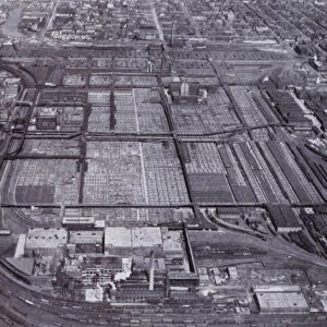
Canvas Print : MAP: CHICAGO, 1874. Map of Chicago, Illinois, and its suburbs. Line engraving, 1874, by Rufus Blanchard


![]()
Canvas Prints from Granger
MAP: CHICAGO, 1874. Map of Chicago, Illinois, and its suburbs. Line engraving, 1874, by Rufus Blanchard
Granger holds millions of images spanning more than 25,000 years of world history, from before the Stone Age to the dawn of the Space Age
Media ID 7549441
1874 Blanchard Chicago Lake Michigan Rufus Suburb Typeface
20"x16" (51x41cm) Canvas Print
"Step back in time with our vintage Map of Chicago, Illinois, and its suburbs from 1874. This beautiful Canvas Print, sourced from The Granger Collection through Granger Art on Demand, showcases an intricately detailed line engraving by Rufus Blanchard. Perfectly preserved, this historical map offers a captivating glimpse into the past, making it an excellent addition to any home or office decor. Bring a piece of Chicago's rich history into your living space and relive the charm of the 19th century."
Delivered stretched and ready to hang our premium quality canvas prints are made from a polyester/cotton blend canvas and stretched over a 1.25" (32mm) kiln dried knot free wood stretcher bar. Packaged in a plastic bag and secured to a cardboard insert for safe transit.
Canvas Prints add colour, depth and texture to any space. Professionally Stretched Canvas over a hidden Wooden Box Frame and Ready to Hang
Estimated Product Size is 40.6cm x 50.8cm (16" x 20")
These are individually made so all sizes are approximate
Artwork printed orientated as per the preview above, with portrait (vertical) orientation to match the source image.
FEATURES IN THESE COLLECTIONS
> Animals
> Mammals
> Macropodidae
> Rufus
> Animals
> Mammals
> Sciuridae
> Rufus
> Maps and Charts
> Related Images
> North America
> United States of America
> Illinois
> Chicago
EDITORS COMMENTS
This print showcases a remarkable piece of history - the 1874 map of Chicago, Illinois, and its suburbs. Created by Rufus Blanchard, a talented line engraver of his time, this intricate artwork provides a glimpse into the city's landscape during that era. The map reveals the vastness and complexity of Chicago with its detailed depiction of streets, buildings, and landmarks. It highlights the city's proximity to Lake Michigan, emphasizing its importance as a bustling port for trade and transportation. Blanchard's skillful use of line engraving brings out every minute detail on this historical document. The typeface used adds an authentic touch to the overall aesthetic appeal. As we gaze upon this print today, it transports us back in time to late 19th-century America when Chicago was rapidly evolving into one of the nation's major metropolises. We can almost imagine horse-drawn carriages traversing these streets or hear echoes from bustling markets and lively conversations. This print is not just an artistic masterpiece but also serves as a valuable educational resource for historians and enthusiasts alike who wish to explore Chicago's past. Its presence in The Granger Collection reminds us how art can preserve our heritage and connect us with our roots.
MADE IN AUSTRALIA
Safe Shipping with 30 Day Money Back Guarantee
FREE PERSONALISATION*
We are proud to offer a range of customisation features including Personalised Captions, Color Filters and Picture Zoom Tools
SECURE PAYMENTS
We happily accept a wide range of payment options so you can pay for the things you need in the way that is most convenient for you
* Options may vary by product and licensing agreement. Zoomed Pictures can be adjusted in the Cart.