Canvas Print > Arts > Artists > C > Samuel de Champlain
Canvas Print : PLYMOUTH, MA, MAP 1605. Samuel de Champlains map of Port St. Louis, later settled by the English as Plymouth, Massachusetts, drawn during an expedetion of 1605


![]()
Canvas Prints from Granger
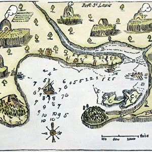
PLYMOUTH, MA, MAP 1605. Samuel de Champlains map of Port St. Louis, later settled by the English as Plymouth, Massachusetts, drawn during an expedetion of 1605
PLYMOUTH, MA, MAP 1605.
Samuel de Champlains map of Port St. Louis, later settled by the English as Plymouth, Massachusetts, drawn during an expedetion of 1605
Granger holds millions of images spanning more than 25,000 years of world history, from before the Stone Age to the dawn of the Space Age
Media ID 6622567
1605 Champlain Colony Samuel Settlement Topography Wood Cut
20"x16" (51x41cm) Canvas Print
Discover history with our stunning Canvas Print of Plymouth, MA, featuring Samuel de Champlains map of Port St. Louis from 1605. This captivating piece, sourced from The Granger Collection in New York, showcases the early exploration of the New World by the renowned French explorer. Bring a piece of history into your home or office with this intricately detailed and beautifully preserved map, expertly printed on high-quality canvas for a vibrant and long-lasting display. Experience the rich history of Plymouth, Massachusetts, and the settling of the English colonies in North America, with this exquisite work of art. Order now and step back in time.
Delivered stretched and ready to hang our premium quality canvas prints are made from a polyester/cotton blend canvas and stretched over a 1.25" (32mm) kiln dried knot free wood stretcher bar. Packaged in a plastic bag and secured to a cardboard insert for safe transit.
Canvas Prints add colour, depth and texture to any space. Professionally Stretched Canvas over a hidden Wooden Box Frame and Ready to Hang
Estimated Product Size is 50.8cm x 40.6cm (20" x 16")
These are individually made so all sizes are approximate
Artwork printed orientated as per the preview above, with landscape (horizontal) orientation to match the source image.
FEATURES IN THESE COLLECTIONS
> Arts
> Artists
> C
> Samuel de Champlain
> Arts
> Landscape paintings
> Waterfall and river artworks
> River artworks
> Maps and Charts
> Related Images
> North America
> Related Images
> Granger Art on Demand
> Maps
EDITORS COMMENTS
This print showcases Samuel de Champlain's map of Port St. Louis, which would later become known as Plymouth, Massachusetts. Created during his 1605 expedition, this woodcut map provides a fascinating glimpse into the early settlement and colonization of North America. Champlain's meticulous attention to detail is evident in this topographical masterpiece. The intricate lines and precise markings reveal the contours of the land, highlighting the river that flows through Port St. Louis. This map serves as both a historical document and a work of art, capturing an important moment in American history. The significance of this map lies not only in its accuracy but also in its connection to the English settlers who would eventually make Plymouth their home. It symbolizes the beginning of a new chapter for these colonists as they embarked on their journey towards establishing one of the most influential colonies in American history. As we gaze upon this remarkable piece from The Granger Collection, New York, we are transported back to 1605 when exploration and discovery were at their peak. It reminds us of our roots and how far we have come since those early days. Whether you are an avid historian or simply appreciate beautiful artwork, this print encapsulates both elements seamlessly. It serves as a reminder that every place has its own unique story waiting to be uncovered and shared with future generations.
MADE IN AUSTRALIA
Safe Shipping with 30 Day Money Back Guarantee
FREE PERSONALISATION*
We are proud to offer a range of customisation features including Personalised Captions, Color Filters and Picture Zoom Tools
SECURE PAYMENTS
We happily accept a wide range of payment options so you can pay for the things you need in the way that is most convenient for you
* Options may vary by product and licensing agreement. Zoomed Pictures can be adjusted in the Cart.