Canvas Print > Europe > France > Canton > Tarn
Canvas Print : Map of Tarn, France


![]()
Canvas Prints from Liszt Collection
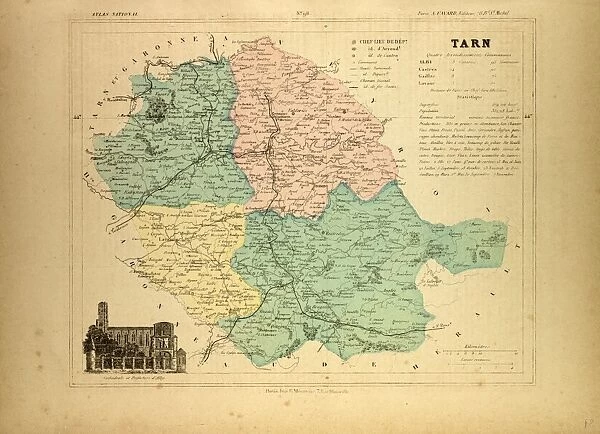
Map of Tarn, France
MAP OF TARN, FRANCE
Liszt Collection of nineteenth-century engravings and images to browse and enjoy
Media ID 12974935
© Quint Lox Limited
20"x16" (51x41cm) Canvas Print
Breathe new life into your space with our exquisite Canvas Print of "Map of Tarn, France" by 000030 from the esteemed Liszt Collection. This captivating artwork beautifully renders the intricate details of the Tarn region's topography, inviting you to explore its rich history and natural beauty. Our premium canvas prints are meticulously crafted with high-quality materials to ensure vibrant colors and sharp details, making this piece an exceptional addition to any home or office. Experience the allure of France's scenic landscapes in a whole new way with our Canvas Print of Map of Tarn, France by 000030.
Delivered stretched and ready to hang our premium quality canvas prints are made from a polyester/cotton blend canvas and stretched over a 1.25" (32mm) kiln dried knot free wood stretcher bar. Packaged in a plastic bag and secured to a cardboard insert for safe transit.
Canvas Prints add colour, depth and texture to any space. Professionally Stretched Canvas over a hidden Wooden Box Frame and Ready to Hang
Estimated Product Size is 50.8cm x 40.6cm (20" x 16")
These are individually made so all sizes are approximate
Artwork printed orientated as per the preview above, with landscape (horizontal) orientation to match the source image.
FEATURES IN THESE COLLECTIONS
> Europe
> France
> Canton
> Tarn
> Maps and Charts
> Related Images
> Liszt Collection
> Engravings
> France
EDITORS COMMENTS
This print showcases a mesmerizing "Map of Tarn, France" from the nineteenth century. With its intricate engravement and illustrative technique, this vintage piece takes us on a journey through history. The map's retro-styled charm exudes an air of Victorian elegance and transports us to a bygone era. The Map of Tarn, France is meticulously detailed, offering a comprehensive view of the region's geography and landmarks. From sprawling landscapes to charming villages, every corner is beautifully depicted with artistic precision. This engraved image not only serves as a navigational tool but also as an exquisite work of art that captures the essence of French culture. As we delve into this historical gem, it becomes evident that each stroke tells a story. The delicate lines and ornate patterns evoke nostalgia for simpler times when maps were meticulously crafted by skilled artisans. It reminds us to appreciate the craftsmanship behind such creations in our modern digital age. The Liszt Collection has once again curated an extraordinary piece that seamlessly blends arts and culture with its retro allure. Whether you are an avid collector or simply captivated by history, this print will undoubtedly add sophistication and intrigue to any space it graces.
MADE IN AUSTRALIA
Safe Shipping with 30 Day Money Back Guarantee
FREE PERSONALISATION*
We are proud to offer a range of customisation features including Personalised Captions, Color Filters and Picture Zoom Tools
SECURE PAYMENTS
We happily accept a wide range of payment options so you can pay for the things you need in the way that is most convenient for you
* Options may vary by product and licensing agreement. Zoomed Pictures can be adjusted in the Cart.