
Canvas Print > Arts > Artists > W > Frederick de Wit
Canvas Print : Map Accuratissima dominii Veneti Italia ducatus Parmae


![]()
Canvas Prints from Liszt Collection
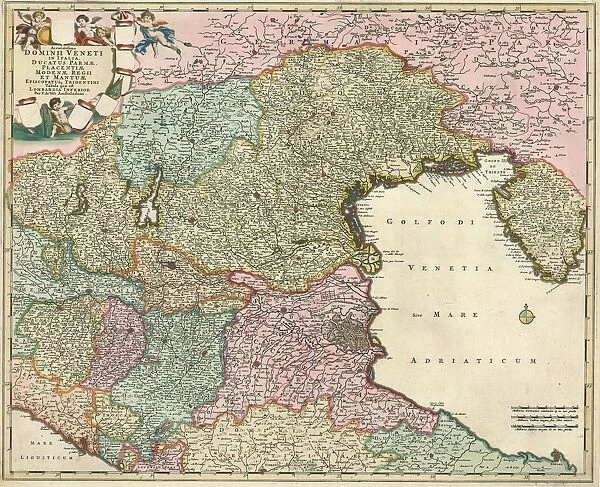
Map Accuratissima dominii Veneti Italia ducatus Parmae
Map, Accuratissima dominii Veneti in Italia, ducatus Parmae, Placentiae Modenae regii et Mantuae episcopatusq. Tridentini tabula quae est Lombardia Inferior, Frederick de Wit (1630-1706), Copperplate print
Liszt Collection of nineteenth-century engravings and images to browse and enjoy
Media ID 19586780
© Artokoloro
1630 1706 Copperplate Print Frederick De Wit
20"x16" (51x41cm) Canvas Print
Discover the captivating beauty of history with our Media Storehouse Canvas Prints. This exquisite piece showcases the "Accuratissima dominii Veneti in Italia, ducatus Parmae" map from the renowned Liszt Collection. Dating back to the 17th century, this intricately detailed map, created by Frederick de Wit, depicts the Duchy of Parma, Placentia, Modena, and Reggio, as well as the episcopates of Tridentini Tabula Quae Est Lombardia Inferior. Bring a touch of old-world charm and historical significance to your home or office with this stunning canvas print, perfect for those who appreciate the richness of the past.
Delivered stretched and ready to hang our premium quality canvas prints are made from a polyester/cotton blend canvas and stretched over a 1.25" (32mm) kiln dried knot free wood stretcher bar. Packaged in a plastic bag and secured to a cardboard insert for safe transit.
Canvas Prints add colour, depth and texture to any space. Professionally Stretched Canvas over a hidden Wooden Box Frame and Ready to Hang
Estimated Product Size is 50.8cm x 40.6cm (20" x 16")
These are individually made so all sizes are approximate
Artwork printed orientated as per the preview above, with landscape (horizontal) orientation to match the source image.
FEATURES IN THESE COLLECTIONS
> Arts
> Artists
> W
> Frederick de Wit
> Maps and Charts
> Related Images
EDITORS COMMENTS
This stunning copperplate print, titled "Map Accuratissima dominii Veneti Italia ducatus Parmae" is a true masterpiece by Frederick de Wit. Created in the 17th century, this map showcases an incredibly detailed and accurate representation of the Venetian domain in Italy, including the duchy of Parma, Placentiae Modenae regii et Mantuae episcopatusq. , and Tridentini tabula quae est Lombardia Inferior. De Wit's intricate craftsmanship is evident in every aspect of this print. The delicate lines and precise engravings bring to life the geographical features of the region with unparalleled accuracy. From rivers meandering through lush landscapes to cities marked with tiny symbols, each element on this map has been meticulously rendered. As you explore this remarkable piece of cartography, you can't help but marvel at De Wit's attention to detail. The vibrant colors used to highlight different territories add depth and richness to the overall composition. This print not only serves as a navigational tool but also as a work of art that captures the essence and grandeur of Italy during that era. Whether you are an avid collector or simply appreciate historical artifacts, this copperplate print from Liszt Collection will undoubtedly be a prized possession for any enthusiast. It provides a fascinating glimpse into the past while showcasing De Wit's exceptional talent as one of history's most renowned cartographers.
MADE IN AUSTRALIA
Safe Shipping with 30 Day Money Back Guarantee
FREE PERSONALISATION*
We are proud to offer a range of customisation features including Personalised Captions, Color Filters and Picture Zoom Tools
SECURE PAYMENTS
We happily accept a wide range of payment options so you can pay for the things you need in the way that is most convenient for you
* Options may vary by product and licensing agreement. Zoomed Pictures can be adjusted in the Cart.