Canvas Print > Animals > Mammals > Cricetidae > Meridionalis
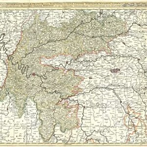
Canvas Print : Map Comitatus Artesiae et Flandriae Meridionalis et regionum circumj


![]()
Canvas Prints from Liszt Collection
Map Comitatus Artesiae et Flandriae Meridionalis et regionum circumj
Map, Comitatus Artesiae et Flandriae Meridionalis et regionum circumjacentium nova descriptio =, Guillaume Delisle (1675-1726), Copperplate print
Liszt Collection of nineteenth-century engravings and images to browse and enjoy
Media ID 19586311
© Artokoloro
1675 1726 Copperplate Print Guillaume Delisle
20"x16" (51x41cm) Canvas Print
Introducing the Media Storehouse Canvas Prints, featuring an exquisite antique map from the Liszt Collection. This stunning piece, titled "Comitatus Artesiae et Flandriae Meridionalis et regionum circumjacentium nova descriptio," is a copperplate print by renowned cartographer Guillaume Delisle. Dating back to 1675-1726, this map beautifully illustrates the southern counties of Artois and Flanders, along with surrounding regions. Bring history into your home with this captivating and intricately detailed canvas print. Each print is meticulously crafted using high-quality materials and vibrant colors, ensuring a beautiful addition to any space. Experience the rich history and artistry of the past with Media Storehouse Canvas Prints.
Delivered stretched and ready to hang our premium quality canvas prints are made from a polyester/cotton blend canvas and stretched over a 1.25" (32mm) kiln dried knot free wood stretcher bar. Packaged in a plastic bag and secured to a cardboard insert for safe transit.
Canvas Prints add colour, depth and texture to any space. Professionally Stretched Canvas over a hidden Wooden Box Frame and Ready to Hang
Estimated Product Size is 50.8cm x 40.6cm (20" x 16")
These are individually made so all sizes are approximate
Artwork printed orientated as per the preview above, with landscape (horizontal) orientation to match the source image.
FEATURES IN THESE COLLECTIONS
> Animals
> Mammals
> Cricetidae
> Meridionalis
> Animals
> Mammals
> Sciuridae
> Meridionalis
> Maps and Charts
> Related Images
EDITORS COMMENTS
This copperplate print, titled "Map Comitatus Artesiae et Flandriae Meridionalis et regionum circumjacentium nova descriptio" is a masterpiece by the renowned cartographer Guillaume Delisle (1675-1726). Delisle's meticulous attention to detail and precision in his maps are evident in this stunning piece. The map showcases the southern regions of Artois and Flanders, along with their surrounding areas. Every line and contour on this print has been carefully engraved onto the copperplate, resulting in an intricate depiction of the landscape. From rivers snaking through towns to mountains rising majestically in the distance, every feature is captured with remarkable accuracy. Delisle's expertise shines through as he presents not only geographical information but also historical context. The names of cities, villages, and landmarks are meticulously labeled, providing invaluable insights into the cultural heritage of these regions during that era. As we gaze upon this exquisite work of art from Liszt Collection, we can't help but be transported back in time. It serves as a window into history—a testament to Delisle's mastery and dedication to his craft. This print would make a perfect addition for any enthusiast or collector who appreciates both beauty and historical significance
MADE IN AUSTRALIA
Safe Shipping with 30 Day Money Back Guarantee
FREE PERSONALISATION*
We are proud to offer a range of customisation features including Personalised Captions, Color Filters and Picture Zoom Tools
SECURE PAYMENTS
We happily accept a wide range of payment options so you can pay for the things you need in the way that is most convenient for you
* Options may vary by product and licensing agreement. Zoomed Pictures can be adjusted in the Cart.