
Canvas Print > Arts > Artists > W > Frederick de Wit
Canvas Print : Map Corectissima nec non novissima dominii et provinciae Groningae e


![]()
Canvas Prints from Liszt Collection
Map Corectissima nec non novissima dominii et provinciae Groningae e
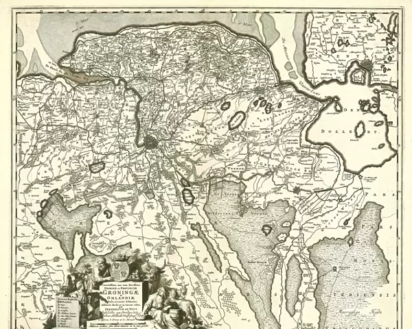
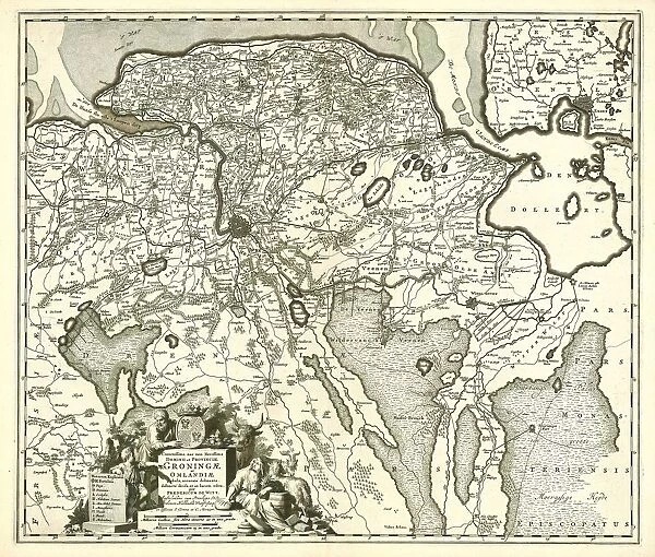
Map, Corectissima nec non novissima dominii et provinciae Groningae et Omlandiae tabula, Frederick de Wit (1630-1706), Copperplate print
Liszt Collection of nineteenth-century engravings and images to browse and enjoy
Media ID 19587166
© Artokoloro
1630 1706 Copperplate Print Frederick De Wit
20"x16" (51x41cm) Canvas Print
Introducing the Media Storehouse Canvas Prints, featuring the exquisite and historically significant Map Corectissima nec non novissima dominii et provinciae Groningae et Omlandiae tabula from the esteemed Liszt Collection. This stunning copperplate print, created by Frederick de Wit in 1630, showcases an intricately detailed map of the dominion and province of Groningen and Omlandia. Each print is meticulously transferred onto high-quality canvas, ensuring vibrant colors and sharp details that bring the historical beauty to life. Elevate your home or office decor with this unique and captivating piece of art.
Delivered stretched and ready to hang our premium quality canvas prints are made from a polyester/cotton blend canvas and stretched over a 1.25" (32mm) kiln dried knot free wood stretcher bar. Packaged in a plastic bag and secured to a cardboard insert for safe transit.
Canvas Prints add colour, depth and texture to any space. Professionally Stretched Canvas over a hidden Wooden Box Frame and Ready to Hang
Estimated Product Size is 50.8cm x 40.6cm (20" x 16")
These are individually made so all sizes are approximate
Artwork printed orientated as per the preview above, with landscape (horizontal) orientation to match the source image.
FEATURES IN THESE COLLECTIONS
> Arts
> Artists
> W
> Frederick de Wit
> Maps and Charts
> Related Images
EDITORS COMMENTS
This print showcases the exquisite "Map Corectissima nec non novissima dominii et provinciae Groningae e" by Frederick de Wit, a renowned cartographer from the 17th century. With its intricate details and meticulous craftsmanship, this copperplate print transports us back in time to explore the dominion and province of Groningen. De Wit's expertise is evident in every stroke of his pen as he accurately depicts the geographical features and boundaries of this region. The map presents a comprehensive overview, encompassing not only Groningen but also Omlandia, providing an insightful glimpse into their interconnectedness. As we delve deeper into this remarkable artwork, we are captivated by the precision with which De Wit has captured rivers, cities, forests, and other landmarks that define these territories. Each element is intricately labeled with utmost clarity, allowing us to navigate through history effortlessly. The Liszt Collection has skillfully preserved this historical treasure for all enthusiasts of cartography and history alike. This print serves as a testament to their commitment to showcasing rare artifacts that bridge past eras with our present-day fascination for exploration. Whether you are an avid collector or simply intrigued by maps' beauty and significance throughout time, this stunning print will undoubtedly add depth and character to any space it graces. Immerse yourself in the rich history depicted on this masterpiece – let your imagination wander through centuries gone by while marveling at De Wit's extraordinary talent.
MADE IN AUSTRALIA
Safe Shipping with 30 Day Money Back Guarantee
FREE PERSONALISATION*
We are proud to offer a range of customisation features including Personalised Captions, Color Filters and Picture Zoom Tools
SECURE PAYMENTS
We happily accept a wide range of payment options so you can pay for the things you need in the way that is most convenient for you
* Options may vary by product and licensing agreement. Zoomed Pictures can be adjusted in the Cart.