Canvas Print > Arts > Artists > H > Henricus Hondius
Canvas Print : Map Nova totivs terrarvm orbis geographica ac hydrographica tabvla a


![]()
Canvas Prints from Liszt Collection
Map Nova totivs terrarvm orbis geographica ac hydrographica tabvla a
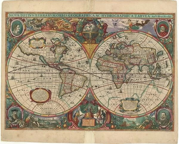
Map, Nova totivs terrarvm orbis geographica ac hydrographica tabvla auct. Henr. Hondio, Henricus Hondius (1597-1651), Copperplate print
Liszt Collection of nineteenth-century engravings and images to browse and enjoy
Media ID 19584774
© Artokoloro
20"x16" (51x41cm) Canvas Print
Discover the captivating allure of the past with Media Storehouse's Canvas Prints featuring the exquisite Map "Nova totivs terrarvm orbis geographica ac hydrographica tabvla a" from the renowned Liszt Collection. This stunning copperplate print, created by Henricus Hondius in 1597, showcases a detailed and intricately designed world map, brimming with historical significance. Each Canvas Print is meticulously crafted with premium materials and high-definition printing techniques, ensuring a vibrant and lifelike representation of this precious piece of cartographic history. Elevate your home or office decor with this timeless masterpiece and transport yourself to a world of exploration and discovery.
Delivered stretched and ready to hang our premium quality canvas prints are made from a polyester/cotton blend canvas and stretched over a 1.25" (32mm) kiln dried knot free wood stretcher bar. Packaged in a plastic bag and secured to a cardboard insert for safe transit.
Canvas Prints add colour, depth and texture to any space. Professionally Stretched Canvas over a hidden Wooden Box Frame and Ready to Hang
Estimated Product Size is 50.8cm x 40.6cm (20" x 16")
These are individually made so all sizes are approximate
Artwork printed orientated as per the preview above, with landscape (horizontal) orientation to match the source image.
FEATURES IN THESE COLLECTIONS
> Arts
> Artists
> H
> Henricus Hondius
> Maps and Charts
> Related Images
EDITORS COMMENTS
This print showcases a remarkable piece of cartographic art titled "Map Nova totivs terrarvm orbis geographica ac hydrographica tabvla a" by Henricus Hondius. Created in the late 16th century, this copperplate print is an exquisite representation of the world's geography and hydrography during that era. The map itself is a testament to Hondius' mastery as a cartographer, with intricate details meticulously etched onto the copperplate. From continents to oceans, every corner of the globe is depicted with utmost precision and artistic flair. The vibrant colors used bring life to this historical document, making it truly mesmerizing. Henricus Hondius was renowned for his expertise in creating maps that were not only accurate but also visually stunning. His dedication to detail can be seen in every stroke on this masterpiece. As we gaze upon this photo print, we are transported back in time, marveling at how our understanding of the world has evolved over centuries. This particular photograph captures the essence and beauty of Hondius' work flawlessly. It serves as a reminder of our planet's rich history and diverse landscapes while honoring the craftsmanship and artistry behind such extraordinary creations
MADE IN AUSTRALIA
Safe Shipping with 30 Day Money Back Guarantee
FREE PERSONALISATION*
We are proud to offer a range of customisation features including Personalised Captions, Color Filters and Picture Zoom Tools
SECURE PAYMENTS
We happily accept a wide range of payment options so you can pay for the things you need in the way that is most convenient for you
* Options may vary by product and licensing agreement. Zoomed Pictures can be adjusted in the Cart.