Canvas Print > Europe > United Kingdom > England > Bristol > Bristol
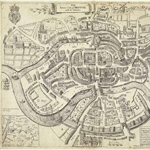
Canvas Print : Bristol map, 1878


![]()
Canvas Prints from Mary Evans Picture Library
Bristol map, 1878
A map of Bristol in 1878. Date: 1878
Mary Evans Picture Library makes available wonderful images created for people to enjoy over the centuries
Media ID 14221401
© Mary Evans Picture Library
30"x20" (76x51cm) Canvas Print
Discover the rich history of Bristol with our stunning Canvas Print of the "Bristol map, 1878" from Media Storehouse. This beautiful print, sourced from Mary Evans Prints Online, showcases an intricately detailed map of the city as it appeared in 1878. Travel back in time and adorn your walls with this captivating piece of historical cartography. Perfect for history enthusiasts, map collectors, or anyone who appreciates the charm of vintage maps, this Canvas Print is sure to make a unique and thoughtful addition to your home or office decor. Our high-quality canvas and vibrant printing process ensures a long-lasting and eye-catching display. Bring the past to life with Media Storehouse's Canvas Print of the "Bristol map, 1878."
Delivered stretched and ready to hang our premium quality canvas prints are made from a polyester/cotton blend canvas and stretched over a 1.25" (32mm) kiln dried knot free wood stretcher bar. Packaged in a plastic bag and secured to a cardboard insert for safe transit.
Canvas Prints add colour, depth and texture to any space. Professionally Stretched Canvas over a hidden Wooden Box Frame and Ready to Hang
Estimated Product Size is 76.2cm x 50.8cm (30" x 20")
These are individually made so all sizes are approximate
Artwork printed orientated as per the preview above, with landscape (horizontal) orientation to match the source image.
FEATURES IN THESE COLLECTIONS
> Europe
> United Kingdom
> England
> Bristol
> Bristol
> Europe
> United Kingdom
> England
> Maps
> Europe
> United Kingdom
> England
> Posters
> Europe
> United Kingdom
> England
> Related Images
> Maps and Charts
> Early Maps
> Maps and Charts
> Related Images
EDITORS COMMENTS
1878: A Glimpse into the Past - A Historical Exploration of Bristol as Revealed in this Detailed Map Step back in time with this map of Bristol, England, dating back to the year 1878. This intricately detailed and historically rich map offers a unique perspective into the layout and character of the city during the 1870s. The map, produced in 1878, showcases the city's streets, waterways, and topography with remarkable accuracy. The bustling port city, located in the southwest of England, is depicted with its intricate network of canals, the River Avon, and the iconic Suspension Bridge. The map also reveals the city's urban development, with various districts, parks, and landmarks clearly marked. As you explore the map, you'll notice the presence of several key historical sites, such as the Old City, St. Augustine's Abbey, and the Royal Fort House. These landmarks offer a glimpse into the rich history of the city, which dates back to the Roman and medieval periods. Moreover, the map provides a fascinating insight into the transportation infrastructure of the time, with horse-drawn trams, railways, and ferries connecting various parts of the city. This not only highlights the city's connectivity but also underscores the importance of transportation in shaping the urban landscape. This map is an essential resource for anyone interested in the history of Bristol or the United Kingdom during the late 19th century. It offers a captivating window into the past, allowing us to explore the city's history, architecture, and urban development in a way that is both informative and visually engaging. So take a moment to immerse yourself in this intriguing piece of history and discover the stories that lie hidden within the streets, canals, and landmarks of 1878's Bristol.
MADE IN AUSTRALIA
Safe Shipping with 30 Day Money Back Guarantee
FREE PERSONALISATION*
We are proud to offer a range of customisation features including Personalised Captions, Color Filters and Picture Zoom Tools
SECURE PAYMENTS
We happily accept a wide range of payment options so you can pay for the things you need in the way that is most convenient for you
* Options may vary by product and licensing agreement. Zoomed Pictures can be adjusted in the Cart.