Canvas Print > Europe > Bulgaria > Maps
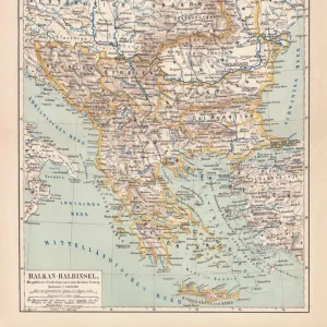
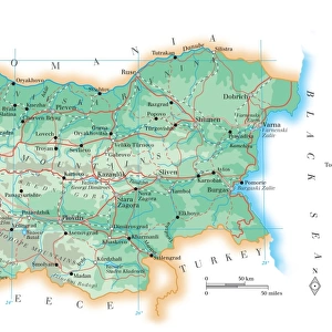
Canvas Print : Map of the Balkans, highlighting Greek and Turkish territory


![]()
Canvas Prints from Mary Evans Picture Library
Map of the Balkans, highlighting Greek and Turkish territory
Postcard map showing the Balkans, highlighting Greek and Turkish territory
Mary Evans Picture Library makes available wonderful images created for people to enjoy over the centuries
Media ID 4396487
© Mary Evans Picture Library 2015 - https://copyrighthub.org/s0/hub1/creation/maryevans/MaryEvansPictureID/10270966
Balkan Balkans Bulgaria Crescent Moon Romania Territories Territory Racial
30"x20" (76x51cm) Canvas Print
Discover the rich history and cultural connections of the Balkans with our stunning Canvas Print of the "Map of the Balkans, highlighting Greek and Turkish territory," exclusively available at Media Storehouse. This captivating postcard map, sourced from Mary Evans Prints Online, brings a unique blend of education and aesthetics to your living space. The intricate details of the map showcase the historical boundaries between Greek and Turkish territories, making it an excellent conversation starter and a beautiful addition to any room. Our high-quality Canvas Prints are not only visually appealing but also long-lasting, ensuring your cherished memory of the Balkans remains vibrant for years to come. Embrace the essence of history and geography with our exquisite Map of the Balkans Canvas Print. Order yours today and let the story unfold at your home.
Delivered stretched and ready to hang our premium quality canvas prints are made from a polyester/cotton blend canvas and stretched over a 1.25" (32mm) kiln dried knot free wood stretcher bar. Packaged in a plastic bag and secured to a cardboard insert for safe transit.
Canvas Prints add colour, depth and texture to any space. Professionally Stretched Canvas over a hidden Wooden Box Frame and Ready to Hang
Estimated Product Size is 50.8cm x 76.2cm (20" x 30")
These are individually made so all sizes are approximate
Artwork printed orientated as per the preview above, with portrait (vertical) orientation to match the source image.
FEATURES IN THESE COLLECTIONS
> Asia
> Turkey
> Related Images
> Europe
> Bulgaria
> Related Images
> Europe
> Greece
> Related Images
> Europe
> Romania
> Related Images
EDITORS COMMENTS
This postcard map of the Balkans, highlighting Greek and Turkish territory, offers a glimpse into the complex history and territorial disputes that have shaped this region for centuries. The intricate details on the map showcase not only the geographical boundaries but also the cultural diversity and historical significance of these lands.
The presence of soldiers in traditional costumes adds a sense of authenticity to the depiction, reminding us of the countless battles fought over these territories throughout history. The crescent moon symbolizes Turkey's influence in the region, while Greece's prominent position highlights its enduring connection to ancient civilizations.
From Romania to Bulgaria, each territory represented on this map tells a story of conquests, alliances, and rivalries that have defined the Balkans for generations. The ruins scattered across the landscape serve as poignant reminders of past conflicts and struggles for power.
As we study this map closely, we are reminded of how borders can shift and identities can evolve over time. It is a testament to the resilience and adaptability of the people who have called these lands home, despite facing numerous challenges along their journey through history.
MADE IN AUSTRALIA
Safe Shipping with 30 Day Money Back Guarantee
FREE PERSONALISATION*
We are proud to offer a range of customisation features including Personalised Captions, Color Filters and Picture Zoom Tools
SECURE PAYMENTS
We happily accept a wide range of payment options so you can pay for the things you need in the way that is most convenient for you
* Options may vary by product and licensing agreement. Zoomed Pictures can be adjusted in the Cart.