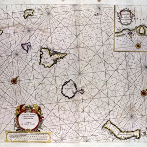
Canvas Print : Map of Palma, Gomera and Hierro, Canary Islands


![]()
Canvas Prints from Mary Evans Picture Library
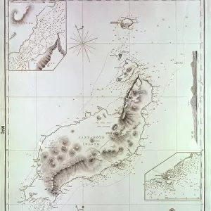
Map of Palma, Gomera and Hierro, Canary Islands
Map of Palma, Gomera and Hierro (or Ferro), Canary Islands, with soundings in fathoms. Date: 1837
Mary Evans Picture Library makes available wonderful images created for people to enjoy over the centuries
Media ID 14262789
© Mary Evans / Pharcide
1830s 1837 Atlantic Canaries Canary Chart Charts Ferro Hierro Maps Navigation Palma Soundings Fathoms Gomera
20"x16" (51x41cm) Canvas Print
Add a touch of exotic charm to your home decor with our stunning Canvas Print of the Map of Palma, Gomera and Hierro (or Ferro) Islands from the year 1837. This beautiful vintage map, sourced from Mary Evans Prints Online, showcases the intricate details of the Canary Islands in a unique and captivating way. The map features soundings in fathoms, adding an authentic nautical touch. Our high-quality Canvas Prints are made to order and printed using archival inks to ensure longevity, making this a perfect addition to any room in your home or office. Bring the beauty of the Canary Islands into your space with this exquisite piece of art.
Delivered stretched and ready to hang our premium quality canvas prints are made from a polyester/cotton blend canvas and stretched over a 1.25" (32mm) kiln dried knot free wood stretcher bar. Packaged in a plastic bag and secured to a cardboard insert for safe transit.
Canvas Prints add colour, depth and texture to any space. Professionally Stretched Canvas over a hidden Wooden Box Frame and Ready to Hang
Estimated Product Size is 50.8cm x 40.6cm (20" x 16")
These are individually made so all sizes are approximate
Artwork printed orientated as per the preview above, with landscape (horizontal) orientation to match the source image.
EDITORS COMMENTS
This map print, dated 1837, showcases the intricate details of Palma, Gomera, and Hierro, three stunning islands in the Canary Islands group located in the Atlantic Ocean. The map provides an in-depth look at the coastal features, soundings in fathoms, and topographical contours of these islands, offering valuable information for navigators and explorers of the 1830s. The map's vibrant colors and meticulous detail bring to life the unique character of each island. Palma, the largest and most populous of the three, is depicted with its bustling harbor, winding streets, and lush greenery. Gomera, the "Island of the Silent People," is shown with its dramatic cliffs, hidden coves, and the iconic Roque de Agando, a natural rock formation. Hierro, the westernmost island, is represented with its volcanic landscape, rugged coastline, and the picturesque village of Valverde. The map also highlights the rich maritime history of the Canary Islands, with various soundings and depth measurements in fathoms, providing essential navigation data for sailors navigating the Atlantic Ocean. The islands' strategic location in the middle of the Atlantic made them a vital stop for explorers, traders, and travelers throughout history. This map print, a testament to the beauty and intrigue of the Canary Islands, serves as a captivating reminder of the rich maritime heritage and natural wonders that continue to draw visitors to these islands today.
MADE IN AUSTRALIA
Safe Shipping with 30 Day Money Back Guarantee
FREE PERSONALISATION*
We are proud to offer a range of customisation features including Personalised Captions, Color Filters and Picture Zoom Tools
FREE COLORIZATION SERVICE
You can choose advanced AI Colorization for this picture at no extra charge!
SECURE PAYMENTS
We happily accept a wide range of payment options so you can pay for the things you need in the way that is most convenient for you
* Options may vary by product and licensing agreement. Zoomed Pictures can be adjusted in the Cart.