Canvas Print > Europe > France > Canton > Allier
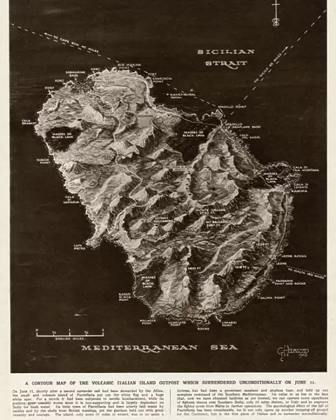
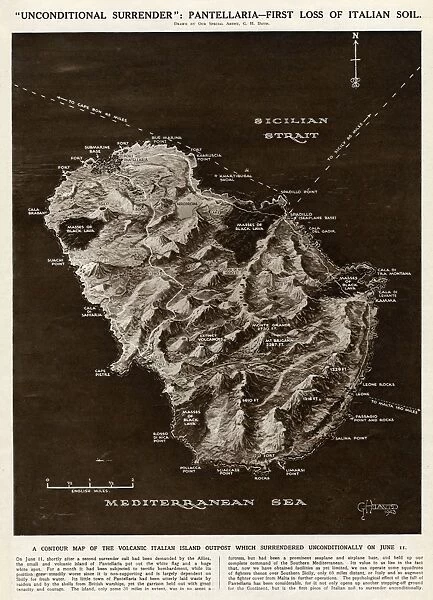
Canvas Print : Map of Pantellaria (Pantelleria) by G. H. Davis
 by G. H. Davis")
 by G. H. Davis")

![]()
Canvas Prints from Mary Evans Picture Library
Map of Pantellaria (Pantelleria) by G. H. Davis
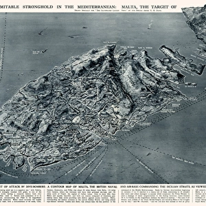
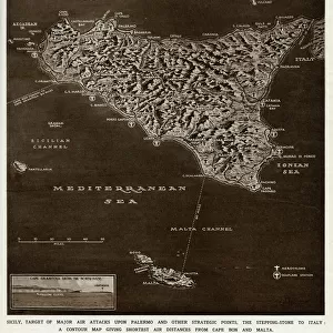
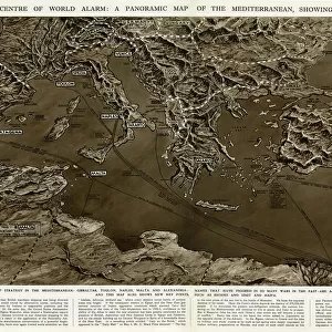
A contour map of Pantellaria (Pantelleria), a volcanic Italian island outpost which surrendered unconditionally on 11 June 1943 -- the first loss of Italian soil to the Allies during the Second World War. It is a small island in the Strait of Sicily, between Sicily and the Tunisian coast. Date: 1943
Mary Evans Picture Library makes available wonderful images created for people to enjoy over the centuries
Media ID 14133385
© Illustrated London News Ltd/Mary Evans
1943 Allies Contour Davis Gain Lava Loss Maps Mediterranean Outpost Sicily Soil Strait Success Surrender Surrendered Volcanic Volcano Unconditional
20"x16" (51x41cm) Canvas Print
Discover the rich history of Pantelleria with our stunning Canvas Print of "Map of Pantelleria (Pantelleria) by G.H. Davis." This exquisite piece, sourced from Mary Evans Prints Online, showcases a detailed contour map of the volcanic Italian island outpost. Known for its strategic importance during World War II, Pantelleria was the first loss of Italian soil to the Allies on 11 June 1943. Bring history into your home or office with this captivating and authentic canvas print, perfect for history enthusiasts, geography aficionados, or anyone looking to add a touch of culture to their space. Our high-quality canvas prints are professionally printed and coated with a protective varnish to ensure vibrant colors and long-lasting beauty. Order yours today and start your collection!
Delivered stretched and ready to hang our premium quality canvas prints are made from a polyester/cotton blend canvas and stretched over a 1.25" (32mm) kiln dried knot free wood stretcher bar. Packaged in a plastic bag and secured to a cardboard insert for safe transit.
Canvas Prints add colour, depth and texture to any space. Professionally Stretched Canvas over a hidden Wooden Box Frame and Ready to Hang
Estimated Product Size is 40.6cm x 50.8cm (16" x 20")
These are individually made so all sizes are approximate
Artwork printed orientated as per the preview above, with portrait (vertical) orientation to match the source image.
FEATURES IN THESE COLLECTIONS
> Africa
> Tunisia
> Related Images
> Europe
> France
> Canton
> Allier
> Europe
> Italy
> Related Images
> Europe
> Italy
> Sicily
> Related Images
> Maps and Charts
> Early Maps
> Maps and Charts
> Italy
> Maps and Charts
> Related Images
EDITORS COMMENTS
This contour map, created by renowned cartographer G.H. Davis in 1943, showcases the volcanic Italian island of Pantelleria, also known as Pantellaria, located in the Mediterranean Sea between Sicily and the Tunisian coast. As the first Italian soil to be lost to the Allies during World War II, Pantelleria holds significant historical importance. The island, a natural outpost with its volcanic terrain, surrendered unconditionally on June 11, 1943. The map reveals the intricate topography of this small yet strategically vital island, with its undulating hills, rugged coastline, and volcanic features. The black lava flows and contour lines illustrate the island's volcanic origins, adding to its unique character. This map serves as a testament to the pivotal moment in wartime history when the Allies gained a strategic success in the Mediterranean, marking a turning point in the 2nd World War. Pantelleria, with its rich history and volcanic landscape, has long been a subject of interest for cartographers and historians alike. This map, a historical artifact from the time, offers a glimpse into the geography and significance of this intriguing island during a pivotal moment in world history.
MADE IN AUSTRALIA
Safe Shipping with 30 Day Money Back Guarantee
FREE PERSONALISATION*
We are proud to offer a range of customisation features including Personalised Captions, Color Filters and Picture Zoom Tools
SECURE PAYMENTS
We happily accept a wide range of payment options so you can pay for the things you need in the way that is most convenient for you
* Options may vary by product and licensing agreement. Zoomed Pictures can be adjusted in the Cart.