
Canvas Print > Maps and Charts > Early Maps
Canvas Print : MAP / GENTILE NATIONS


![]()
Canvas Prints from Mary Evans Picture Library
MAP / GENTILE NATIONS
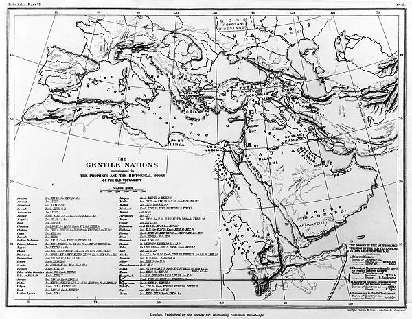
A map of the Gentile Nations, as mentioned in the Prophets and historical books of the Old Testament. Date: BC
Mary Evans Picture Library makes available wonderful images created for people to enjoy over the centuries
Media ID 20157755
© Bubblepunk
Maps Mentioned Nations Prophets Testament Gentile
20"x16" (51x41cm) Canvas Print
Bring the rich history of the Old Testament to life with our exquisite Canvas Prints from Media Storehouse, featuring the captivating "Map of the Gentile Nations" from Mary Evans Prints Online. This intricately detailed map, dating back to ancient times, provides a fascinating glimpse into the biblical world and its diverse peoples. Our high-quality canvas prints are meticulously crafted to bring out the vibrant colors and intricate details of this historical masterpiece, making it a stunning addition to any home or office. Each print is carefully wrapped and shipped to ensure safe delivery, allowing you to enjoy the beauty and depth of this timeless image for years to come.
Delivered stretched and ready to hang our premium quality canvas prints are made from a polyester/cotton blend canvas and stretched over a 1.25" (32mm) kiln dried knot free wood stretcher bar. Packaged in a plastic bag and secured to a cardboard insert for safe transit.
Canvas Prints add colour, depth and texture to any space. Professionally Stretched Canvas over a hidden Wooden Box Frame and Ready to Hang
Estimated Product Size is 50.8cm x 40.6cm (20" x 16")
These are individually made so all sizes are approximate
Artwork printed orientated as per the preview above, with landscape (horizontal) orientation to match the source image.
FEATURES IN THESE COLLECTIONS
> Maps and Charts
> Early Maps
> Maps and Charts
> Related Images
> Mary Evans Prints Online
> New Images July 2020
EDITORS COMMENTS
This ancient map, dating back to Biblical times, depicts the Gentile Nations as mentioned in the Prophets and Historical Books of the Old Testament. The term 'Gentiles' referred to any non-Israelite peoples or nations in the ancient Middle Eastern world. This map provides a fascinating glimpse into the geographical understanding of the world during that era. The map covers the Middle East, North Africa, Europe, and parts of Asia, highlighting various regions and territories inhabited by the Gentile Nations. The Red Sea, the Mediterranean Sea, and the Euphrates and Tigris Rivers are prominently featured, marking the boundaries of several ancient civilizations and empires. The map includes labels for numerous cities, kingdoms, and territories, such as Egypt, Assyria, Babylon, Persia, Greece, and Rome. These places played significant roles in the Old Testament narratives and prophetic visions. For instance, the prophecies of Daniel and Ezekiel refer to the Gentile Nations, specifically the Babylonians, Persians, and Greeks, as influential powers in the history of Israel and the world. This map serves as an essential resource for scholars, historians, and students of the Bible, providing valuable context for understanding the historical and geographical settings of the Old Testament. It also offers a captivating glimpse into the ancient world, shedding light on the rich cultural and historical tapestry that shaped the foundations of Western civilization.
MADE IN AUSTRALIA
Safe Shipping with 30 Day Money Back Guarantee
FREE PERSONALISATION*
We are proud to offer a range of customisation features including Personalised Captions, Color Filters and Picture Zoom Tools
FREE COLORIZATION SERVICE
You can choose advanced AI Colorization for this picture at no extra charge!
SECURE PAYMENTS
We happily accept a wide range of payment options so you can pay for the things you need in the way that is most convenient for you
* Options may vary by product and licensing agreement. Zoomed Pictures can be adjusted in the Cart.


