Canvas Print > Europe > United Kingdom > England > Maps
Canvas Print : Ploughing up England


![]()
Canvas Prints from Mary Evans Picture Library
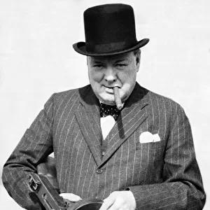
Ploughing up England
Map showing the extent of the Ploughing Up England Campaign designed to maximise farm produce during World War Two
Mary Evans Picture Library makes available wonderful images created for people to enjoy over the centuries
Media ID 4380555
© Mary Evans Picture Library 2015 - https://copyrighthub.org/s0/hub1/creation/maryevans/MaryEvansPictureID/10074794
Campaign Extent Ploughing Produce Designed
30"x20" (76x51cm) Canvas Print
"Step back in time with our stunning Canvas Print from Media Storehouse, featuring the iconic image "Ploughing up England" by Rights Managed from Mary Evans Prints Online. This evocative map illustrates the extent of the Ploughing Up England campaign during World War Two, a pivotal moment in our country's history. Each Canvas Print is meticulously crafted with high-quality materials and vibrant colours, bringing history to life in your home or office. Order yours today and let this powerful piece of art tell a story that resonates with us all."
Delivered stretched and ready to hang our premium quality canvas prints are made from a polyester/cotton blend canvas and stretched over a 1.25" (32mm) kiln dried knot free wood stretcher bar. Packaged in a plastic bag and secured to a cardboard insert for safe transit.
Canvas Prints add colour, depth and texture to any space. Professionally Stretched Canvas over a hidden Wooden Box Frame and Ready to Hang
Estimated Product Size is 50.8cm x 76.2cm (20" x 30")
These are individually made so all sizes are approximate
Artwork printed orientated as per the preview above, with portrait (vertical) orientation to match the source image.
FEATURES IN THESE COLLECTIONS
> Europe
> United Kingdom
> England
> Maps
> Europe
> United Kingdom
> England
> Posters
> Europe
> United Kingdom
> England
> Related Images
> Historic
> World War I and II
> Generals and leaders
> Maps and Charts
> Early Maps
> Maps and Charts
> Related Images
> Maps and Charts
> World
EDITORS COMMENTS
This fascinating print titled "Ploughing up England" offers a glimpse into the extensive campaign that took place during World War Two in Britain. The map displayed shows the strategic efforts made to maximize farm produce by ploughing up vast areas of land across England. This historical image provides insight into the crucial role that farming played in supporting the war effort, as food production was essential for both soldiers on the front lines and civilians back home.
The design of this map highlights the meticulous planning and coordination involved in ensuring that every available piece of land was utilized for agricultural purposes. It serves as a reminder of the sacrifices and hard work undertaken by farmers and agricultural workers during this challenging period in history.
As we reflect on this snapshot from the 1940s, we are reminded of the resilience and determination shown by people across Britain as they came together to support their country during wartime. The Ploughing Up England Campaign is a testament to human ingenuity and resourcefulness in times of crisis, showcasing how communities can unite towards a common goal.
Overall, this print captures a pivotal moment in British history, shedding light on an often overlooked aspect of World War Two - the vital role played by farmers in sustaining their nation through difficult times.
MADE IN AUSTRALIA
Safe Shipping with 30 Day Money Back Guarantee
FREE PERSONALISATION*
We are proud to offer a range of customisation features including Personalised Captions, Color Filters and Picture Zoom Tools
SECURE PAYMENTS
We happily accept a wide range of payment options so you can pay for the things you need in the way that is most convenient for you
* Options may vary by product and licensing agreement. Zoomed Pictures can be adjusted in the Cart.