Canvas Print > Maps and Charts > Related Images
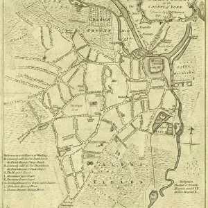
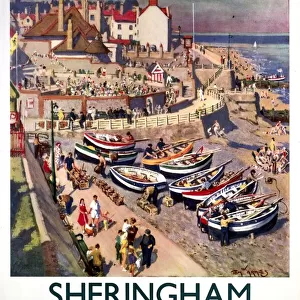
Canvas Print : A Map of Norwood Hall Estate in the Township of Brightside Bierlow and some adjoining Lands of the Duke of Norfolk, 1832


![]()
Canvas Prints from Sheffield City Archives
A Map of Norwood Hall Estate in the Township of Brightside Bierlow and some adjoining Lands of the Duke of Norfolk, 1832
Norwood Hall and Grounds (later known as Bishopholme), Norwood Lane later named Herries Road.Original at Sheffield Local Studies Library:s (15) 1 L
Sheffield City Archives and Local Studies Library has an unrivalled collection of images of Sheffield, England
Media ID 14089389
© Sheffield City Council
Hall Lane Maps Road Herries Norwood Shirecliffe
20"x16" (51x41cm) Canvas Print
Discover the rich history of Norwood Hall Estate with our exquisite Canvas Print of this 1832 map from Sheffield City Archives. This beautifully detailed map showcases Norwood Hall and its surrounding lands, once owned by the Duke of Norfolk. Bring the history of this historic estate into your home or office with our high-quality Canvas Print, expertly printed on heavy-duty canvas for lasting vibrancy and detail. Add a touch of timeless charm to any space with this unique and captivating piece of local history.
Delivered stretched and ready to hang our premium quality canvas prints are made from a polyester/cotton blend canvas and stretched over a 1.25" (32mm) kiln dried knot free wood stretcher bar. Packaged in a plastic bag and secured to a cardboard insert for safe transit.
Canvas Prints add colour, depth and texture to any space. Professionally Stretched Canvas over a hidden Wooden Box Frame and Ready to Hang
Estimated Product Size is 50.8cm x 40.6cm (20" x 16")
These are individually made so all sizes are approximate
Artwork printed orientated as per the preview above, with landscape (horizontal) orientation to match the source image.
FEATURES IN THESE COLLECTIONS
> Europe
> United Kingdom
> England
> Norfolk
> Related Images
> Maps and Charts
> Related Images
> Sheffield City Archives
> Maps and Plans
EDITORS COMMENTS
This print showcases a historical gem, "A Map of Norwood Hall Estate in the Township of Brightside Bierlow and some adjoining Lands of the Duke of Norfolk, 1832". The image takes us back to a time when Norwood Lane was known as Herries Road and Norwood Hall and Grounds were later renamed Bishopholme. Preserved at Sheffield Local Studies Library, this map is a testament to Sheffield's rich heritage. The intricate details on this map offer an intriguing glimpse into the past. It highlights the sprawling estate with its lush grounds, providing insight into how it once stood proudly within the Township of Brightside Bierlow. As we explore every corner of this visual treasure, we can almost imagine ourselves walking through those very lanes that have witnessed centuries unfold. Sheffield City Archives has done an exceptional job preserving this piece for future generations to appreciate. Its significance lies not only in its historical value but also in its ability to transport us back in time. This photograph allows us to connect with our roots and understand how our city has evolved over time. As we delve deeper into Sheffield's history through maps like these, we gain a greater appreciation for our surroundings today. Let us cherish these glimpses from the past and honor those who have worked tirelessly to preserve them for all to see.
MADE IN AUSTRALIA
Safe Shipping with 30 Day Money Back Guarantee
FREE PERSONALISATION*
We are proud to offer a range of customisation features including Personalised Captions, Color Filters and Picture Zoom Tools
SECURE PAYMENTS
We happily accept a wide range of payment options so you can pay for the things you need in the way that is most convenient for you
* Options may vary by product and licensing agreement. Zoomed Pictures can be adjusted in the Cart.
![The Duke of Norfolks estates in Brightside Bierlow, Sheffield, [mid 19th cent]](/sq/716/duke-norfolks-estates-brightside-bierlow-20355002.jpg.webp)