
Canvas Print > Maps and Charts > Africa
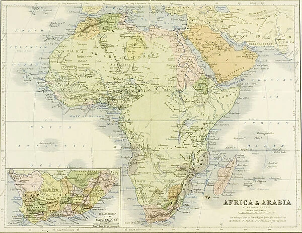
Canvas Print : 19th century map of Africa and Arabia. Engraved and printed in 1869 by W. &A. K. Johnston


![]()
Canvas Prints from Universal Images Group (UIG)
19th century map of Africa and Arabia. Engraved and printed in 1869 by W. &A. K. Johnston
19th century map of Africa and Arabia. Engraved and printed in 1869 by W.&A.K.Johnston
Universal Images Group (UIG) manages distribution for many leading specialist agencies worldwide
Media ID 20165309
© Universal Images Group
Africa Arabia Century Color Colour Welsh
20"x16" (51x41cm) Canvas Print
Step back in time with our exquisite Canvas Print of the 19th century map of Africa and Arabia. Meticulously engraved and printed in 1869 by W. & A. K. Johnston from the Universal History Archive/Universal Images Group, this vintage map transports you to an era of exploration and discovery. Add a touch of history and character to your space with this captivating and intricately detailed piece. Perfect for the office, living room, or as a unique gift. Bring history to life with Media Storehouse Canvas Prints.
Delivered stretched and ready to hang our premium quality canvas prints are made from a polyester/cotton blend canvas and stretched over a 1.25" (32mm) kiln dried knot free wood stretcher bar. Packaged in a plastic bag and secured to a cardboard insert for safe transit.
Canvas Prints add colour, depth and texture to any space. Professionally Stretched Canvas over a hidden Wooden Box Frame and Ready to Hang
Estimated Product Size is 50.8cm x 40.6cm (20" x 16")
These are individually made so all sizes are approximate
Artwork printed orientated as per the preview above, with landscape (horizontal) orientation to match the source image.
FEATURES IN THESE COLLECTIONS
> Maps and Charts
> Related Images
> Universal Images Group (UIG)
> History
> Historical Maps
EDITORS COMMENTS
This print showcases a remarkable piece of history - a 19th-century map of Africa and Arabia. Engraved and printed in 1869 by the renowned cartographers W. &A. K. Johnston, this horizontal map is a true testament to their expertise and attention to detail. The vibrant colors used in this illustration bring life to the various geographical features depicted on the map. As we delve into this fascinating artwork, we are transported back in time, gaining insight into the world as it was during the 19th century. This meticulously crafted map provides us with an invaluable glimpse into the geography of Africa and Arabia during that era. The intricate details captured within this image allow us to explore these vast regions with curiosity and wonder. From lush forests to expansive deserts, from winding rivers to towering mountain ranges, every element has been carefully illustrated for our exploration. Notably, this particular map holds significance as it was engraved by Welsh cartographers who were known for their exceptional craftsmanship. Their dedication shines through each stroke on this masterpiece. Through Universal Images Group (UIG), we have been granted access to witness history unfold before our eyes through this extraordinary photo print. It serves as a reminder of how maps have not only guided explorers but also provided valuable insights into different cultures and civilizations throughout time.
MADE IN AUSTRALIA
Safe Shipping with 30 Day Money Back Guarantee
FREE PERSONALISATION*
We are proud to offer a range of customisation features including Personalised Captions, Color Filters and Picture Zoom Tools
SECURE PAYMENTS
We happily accept a wide range of payment options so you can pay for the things you need in the way that is most convenient for you
* Options may vary by product and licensing agreement. Zoomed Pictures can be adjusted in the Cart.


