Canvas Print > Animals > Mammals > Cricetidae > Orientalis
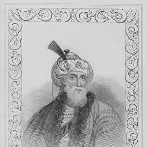
Canvas Print : India Orientalis


![]()
Canvas Prints from Universal Images Group (UIG)
India Orientalis
Near East Map 1606
Universal Images Group (UIG) manages distribution for many leading specialist agencies worldwide
Media ID 23921601
1606 Antiquarian Antiquarian Maps East India Journeys Maps Orient Persia Travels Treks Trip Trips Voyage Voyages Near
20"x16" (51x41cm) Canvas Print
Delivered stretched and ready to hang our premium quality canvas prints are made from a polyester/cotton blend canvas and stretched over a 1.25" (32mm) kiln dried knot free wood stretcher bar. Packaged in a plastic bag and secured to a cardboard insert for safe transit.
Canvas Prints add colour, depth and texture to any space. Professionally Stretched Canvas over a hidden Wooden Box Frame and Ready to Hang
Estimated Product Size is 50.8cm x 40.6cm (20" x 16")
These are individually made so all sizes are approximate
Artwork printed orientated as per the preview above, with landscape (horizontal) orientation to match the source image.
FEATURES IN THESE COLLECTIONS
> Animals
> Mammals
> Cricetidae
> Orientalis
> Asia
> India
> Related Images
> Maps and Charts
> India
> Maps and Charts
> Related Images
> Universal Images Group (UIG)
> History
> Historical Maps
EDITORS COMMENTS
This print titled "India Orientalis (Near East Map 1606)" takes us on a mesmerizing journey back in time. Dating back to the year 1606, this antique map showcases the intricate details of the Near East region, offering a glimpse into the rich history and diverse cultures that once thrived there. With its faded hues and delicate lines, this piece of art evokes a sense of nostalgia for an era long gone. As we gaze upon it, we are transported to a time when travel was arduous yet filled with wonder and discovery. The map's depiction of India, Persia, and other Asian countries invites us to embark on imaginary voyages through these ancient lands. Every corner of this masterpiece holds secrets waiting to be unraveled. It serves as a reminder that our world has always been interconnected; people have embarked on treks and journeys since time immemorial. This map becomes not just an object but also a portal into the past – an opportunity to explore distant lands without leaving our present surroundings. The attention to detail in this antiquarian map is awe-inspiring. Each contour line tells stories of forgotten civilizations, trade routes, and cultural exchanges that shaped the fabric of these regions. It reminds us that history is not merely confined within textbooks but can be brought alive through visual representations like this one. As we admire this remarkable work from Universal Images Group (UIG), let us appreciate its significance in preserving our collective heritage while igniting our curiosity about by
MADE IN AUSTRALIA
Safe Shipping with 30 Day Money Back Guarantee
FREE PERSONALISATION*
We are proud to offer a range of customisation features including Personalised Captions, Color Filters and Picture Zoom Tools
SECURE PAYMENTS
We happily accept a wide range of payment options so you can pay for the things you need in the way that is most convenient for you
* Options may vary by product and licensing agreement. Zoomed Pictures can be adjusted in the Cart.