Canvas Print > Universal Images Group (UIG) > Universal Images Group > Satellite and Aerial > Planet Observer 4
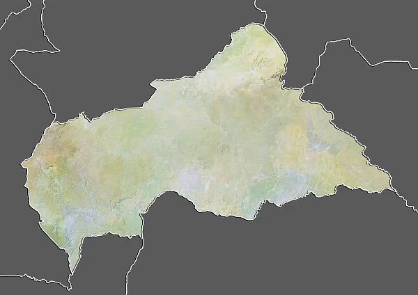
Canvas Print : Central African Republic, Relief Map With Border and Mask


![]()
Canvas Prints from Universal Images Group (UIG)
Central African Republic, Relief Map With Border and Mask
Relief map of Central African Republic (with border and mask). This image was compiled from data acquired by landsat 5 & 7 satellites combined with elevation data
Universal Images Group (UIG) manages distribution for many leading specialist agencies worldwide
Media ID 9618567
© Planet Observer/UIG
Africa Relief Map Central African Republic Satellite View
20"x16" (51x41cm) Canvas Print
Discover the intricacies of Central African geography with our exquisite Canvas Print from Media Storehouse. This stunning relief map, sourced from Universal Images Group (UIG), showcases the Central African Republic's borders in crisp detail, alongside an intriguing mask symbol. Meticulously compiled from satellite data acquired by Landsat 5 & 7, and elevation data, this artwork not only serves as an educational masterpiece but also makes for a captivating conversation starter. Bring the beauty and depth of Central African geography into your home or office with our premium Canvas Print.
Delivered stretched and ready to hang our premium quality canvas prints are made from a polyester/cotton blend canvas and stretched over a 1.25" (32mm) kiln dried knot free wood stretcher bar. Packaged in a plastic bag and secured to a cardboard insert for safe transit.
Canvas Prints add colour, depth and texture to any space. Professionally Stretched Canvas over a hidden Wooden Box Frame and Ready to Hang
Estimated Product Size is 50.8cm x 40.6cm (20" x 16")
These are individually made so all sizes are approximate
Artwork printed orientated as per the preview above, with landscape (horizontal) orientation to match the source image.
EDITORS COMMENTS
This print showcases the Central African Republic in all its geographical glory. The relief map, meticulously compiled from data acquired by landsat 5 & 7 satellites combined with elevation data, offers a stunning visual representation of this landlocked country in Africa. With its vibrant colors and intricate details, the map provides an immersive experience into the physical geography of the region. The image portrays a horizontal view that encompasses not only the topography but also highlights the borders and mask-like features that add a unique cultural touch to this representation. It is evident that great care has been taken to capture every contour and elevation accurately, making it an invaluable tool for cartographers and geographers alike. Located in Bangui, the capital city of Central African Republic, this relief map captures the essence of this diverse nation without any human presence. The absence of people allows us to focus solely on appreciating nature's beauty as depicted through satellite imagery. This photograph print from Universal Images Group (UIG) serves as both an educational resource and a work of art. Its rich colors and detailed depiction make it suitable for display in classrooms or offices where exploration and appreciation for our planet's natural wonders are valued
MADE IN AUSTRALIA
Safe Shipping with 30 Day Money Back Guarantee
FREE PERSONALISATION*
We are proud to offer a range of customisation features including Personalised Captions, Color Filters and Picture Zoom Tools
SECURE PAYMENTS
We happily accept a wide range of payment options so you can pay for the things you need in the way that is most convenient for you
* Options may vary by product and licensing agreement. Zoomed Pictures can be adjusted in the Cart.