Cushion > Arts > Artists > S > John Seller
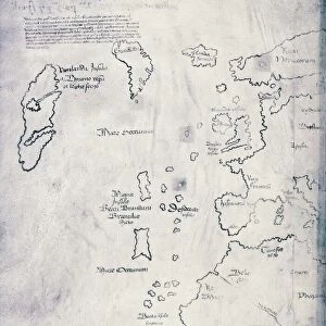
Cushion : A Chart of the Sea Coasts of Russia, Lapland, Finmarke, Nova Zemla and Greenland


![]()
Home Decor from Fine Art Finder
A Chart of the Sea Coasts of Russia, Lapland, Finmarke, Nova Zemla and Greenland
XYC251516 A Chart of the Sea Coasts of Russia, Lapland, Finmarke, Nova Zemla and Greenland, 1671 (engraving) by Seller, John (1632-97); 43.4x52.9 cm; Yale Center for British Art, Paul Mellon Collection, USA; English, out of copyright
Media ID 23362572
© Bridgeman Images
Capes Navigation Navigational Sailing Ship Headlands
Cushion
Refresh your home decor with a beautiful full photo 16"x16" (40x40cm) cushion, complete with cushion pad insert. Printed on both sides and made from 100% polyester with a zipper on the bottom back edge of the cushion cover. Care Instructions: Warm machine wash, do not bleach, do not tumble dry. Warm iron inside out. Do not dry clean.
Accessorise your space with decorative, soft cushions
Estimated Product Size is 40cm x 40cm (15.7" x 15.7")
These are individually made so all sizes are approximate
Artwork printed orientated as per the preview above, with landscape (horizontal) or portrait (vertical) orientation to match the source image.
FEATURES IN THESE COLLECTIONS
> Arts
> Artists
> S
> John Seller
> Europe
> Russia
> Related Images
> Maps and Charts
> Related Images
> North America
> Greenland
> Maps
> North America
> Greenland
> Related Images
> North America
> United States of America
> Maps
> Fine Art Finder
> Artists
> American School
> Fine Art Finder
> Artists
> John Seller
> Fine Art Finder
> Maps (celestial & Terrestrial)
EDITORS COMMENTS
This print showcases "A Chart of the Sea Coasts of Russia, Lapland, Finmarke, Nova Zemla and Greenland" an exquisite engraving created by John Seller in 1671. Measuring 43.4x52.9 cm, this historical artwork is housed at the Yale Center for British Art as part of the esteemed Paul Mellon Collection. The chart depicts a vast expanse of headlands and capes along the sea coasts mentioned above. Its intricate details and precise navigational markings make it a valuable tool for sailors during that era. A majestic sailing ship gracefully glides through the waters, symbolizing both adventure and discovery. Seller's expertise in cartography shines through in this masterpiece as he skillfully captures every contour of these remote regions with meticulous accuracy. The map not only serves practical purposes but also evokes a sense of wonder about uncharted territories waiting to be explored. Bridgeman Images has impeccably reproduced this print, allowing art enthusiasts to appreciate its beauty from afar. As we gaze upon this remarkable piece, we are transported back in time to an era when maps were essential instruments for navigation across treacherous seas. Let us marvel at Seller's craftsmanship and acknowledge his contribution to our understanding of geography and exploration. This photograph invites us to delve into history while reminding us how art can transcend time and connect us with past civilizations' aspirations for knowledge and adventure.
MADE IN AUSTRALIA
Safe Shipping with 30 Day Money Back Guarantee
FREE PERSONALISATION*
We are proud to offer a range of customisation features including Personalised Captions, Color Filters and Picture Zoom Tools
SECURE PAYMENTS
We happily accept a wide range of payment options so you can pay for the things you need in the way that is most convenient for you
* Options may vary by product and licensing agreement. Zoomed Pictures can be adjusted in the Cart.