Cushion > Asia > Afghanistan > Maps
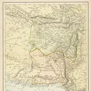
Cushion : A Map of the Kingdom of Kabul (colour litho)
")
")

Please select a smaller print size for this image
![]()
Home Decor from Fine Art Finder
A Map of the Kingdom of Kabul (colour litho)
XCF275023 A Map of the Kingdom of Kabul (colour litho) by English School, (19th century); Private Collection; English, out of copyright
Media ID 12790605
© www.bridgemanimages.com
Afghan Afghanistan Geographical Kabul Mapping Persia
Photo Mug
Refresh your home decor with a beautiful full photo 16"x16" (40x40cm) cushion, complete with cushion pad insert. Printed on both sides and made from 100% polyester with a zipper on the bottom back edge of the cushion cover. Care Instructions: Warm machine wash, do not bleach, do not tumble dry. Warm iron inside out. Do not dry clean.
Accessorise your space with decorative, soft cushions
Estimated Product Size is 9.6cm x 8.1cm (3.8" x 3.2")
These are individually made so all sizes are approximate
Artwork printed orientated as per the preview above, with landscape (horizontal) or portrait (vertical) orientation to match the source image.
FEATURES IN THESE COLLECTIONS
> Asia
> Afghanistan
> Kabul
> Asia
> Afghanistan
> Maps
> Asia
> Afghanistan
> Related Images
> Asia
> Related Images
> Maps and Charts
> Related Images
> Fine Art Finder
> Schools
> English School
EDITORS COMMENTS
This print showcases a remarkable piece of cartographic history - "A Map of the Kingdom of Kabul". Created by an anonymous English School artist in the 19th century, this colour lithograph offers a fascinating glimpse into the geographical landscape of Kabul, Afghanistan. The intricate details and vibrant hues bring to life the rich tapestry of this ancient kingdom. The map not only highlights Kabul but also encompasses significant regions such as Persia and other parts of Asia. Its meticulous craftsmanship allows viewers to explore various cities, rivers, mountains, and landmarks that shaped the region's identity during that era. This artwork serves as a valuable historical resource for those interested in understanding the geopolitical dynamics and cultural heritage of Afghanistan. Stored within a private collection, this rare find is now made accessible through Fine Art Finder's partnership with www. bridgemanimages. com. It invites us to delve into an era when cartography was both an art form and a scientific endeavor. As we examine each contour line and carefully placed label on this map, we are transported back in time to witness how knowledge about distant lands was disseminated. Whether you have an affinity for mapping or simply appreciate visual storytelling at its finest, "A Map of the Kingdom of Kabul" is sure to captivate your imagination. It stands as a testament to human curiosity about our world's vastness while reminding us that even centuries-old maps can still hold relevance today.
MADE IN AUSTRALIA
Safe Shipping with 30 Day Money Back Guarantee
FREE PERSONALISATION*
We are proud to offer a range of customisation features including Personalised Captions, Color Filters and Picture Zoom Tools
SECURE PAYMENTS
We happily accept a wide range of payment options so you can pay for the things you need in the way that is most convenient for you
* Options may vary by product and licensing agreement. Zoomed Pictures can be adjusted in the Cart.