Cushion > North America > United States of America > New York > New York > Maps
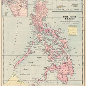
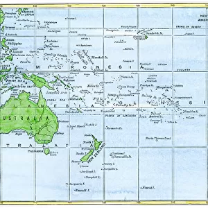
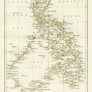
Cushion : Philippines map 1885


![]()
Home Decor from Fine Art Storehouse
Philippines map 1885
Encyclopedia Britannica 9th Edition New York Charles Scribners and Sons 1885 Vol XVIII
Unleash your creativity and transform your space into a visual masterpiece!
THEPALMER
Media ID 14756634
© This content is subject to copyright
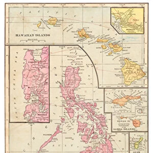
Borneo Island Pacific Ocean Philippines Mindanao
Cushion
Refresh your home decor with a beautiful full photo 16"x16" (40x40cm) cushion, complete with cushion pad insert. Printed on both sides and made from 100% polyester with a zipper on the bottom back edge of the cushion cover. Care Instructions: Warm machine wash, do not bleach, do not tumble dry. Warm iron inside out. Do not dry clean.
Accessorise your space with decorative, soft cushions
Estimated Product Size is 40cm x 40cm (15.7" x 15.7")
These are individually made so all sizes are approximate
Artwork printed orientated as per the preview above, with landscape (horizontal) or portrait (vertical) orientation to match the source image.
FEATURES IN THESE COLLECTIONS
> Arts
> Artists
> O
> Oceanic Oceanic
> Asia
> Philippines
> Maps
> Asia
> Philippines
> Related Images
> Maps and Charts
> Related Images
> North America
> United States of America
> New York
> New York
> Maps
> North America
> United States of America
> New York
> Related Images
> Fine Art Storehouse
> Map
> Historical Maps
EDITORS COMMENTS
This print titled "Philippines map 1885" takes us on a journey back in time to the late 19th century. The image showcases an intricately detailed map of the Philippines, sourced from the esteemed Encyclopedia Britannica's 9th Edition published by Charles Scribners and Sons in New York in 1885. The map offers a glimpse into the geographical landscape of this archipelago nation, highlighting significant landmarks such as Borneo, Mindanao, and the vast Pacific Ocean that surrounds it. Its vintage charm is evident through its aged appearance and delicate lines that trace each island's contours. As we delve deeper into this historical artifact captured by THEPALMER, we are transported to an era when cartography was both artistry and science. This piece not only serves as a visual representation of Philippine geography but also acts as a window into cultural heritage and exploration during that period. With its rich hues and meticulous craftsmanship, this print from Fine Art Storehouse becomes more than just an aesthetic addition to any space; it becomes an educational tool bridging past and present. It invites viewers to appreciate the beauty of our world while igniting curiosity about how these lands have evolved over time. Whether displayed in homes or offices, this remarkable artwork sparks conversations about history, geography, and human progress – reminding us all of our interconnectedness with the past.
MADE IN AUSTRALIA
Safe Shipping with 30 Day Money Back Guarantee
FREE PERSONALISATION*
We are proud to offer a range of customisation features including Personalised Captions, Color Filters and Picture Zoom Tools
SECURE PAYMENTS
We happily accept a wide range of payment options so you can pay for the things you need in the way that is most convenient for you
* Options may vary by product and licensing agreement. Zoomed Pictures can be adjusted in the Cart.