Cushion > North America > United States of America > Massachusetts > Boston
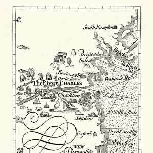
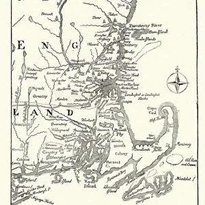
Cushion : Map of Massachusetts 1877


![]()
Home Decor from Fine Art Storehouse
Map of Massachusetts 1877
Warrens Common School Geography 1877
Unleash your creativity and transform your space into a visual masterpiece!
THEPALMER
Media ID 14824583
© This content is subject to copyright
Boston Maine Massachusetts Plymouth Nantucket
Cushion
Refresh your home decor with a beautiful full photo 16"x16" (40x40cm) cushion, complete with cushion pad insert. Printed on both sides and made from 100% polyester with a zipper on the bottom back edge of the cushion cover. Care Instructions: Warm machine wash, do not bleach, do not tumble dry. Warm iron inside out. Do not dry clean.
Accessorise your space with decorative, soft cushions
Estimated Product Size is 40cm x 40cm (15.7" x 15.7")
These are individually made so all sizes are approximate
Artwork printed orientated as per the preview above, with landscape (horizontal) or portrait (vertical) orientation to match the source image.
FEATURES IN THESE COLLECTIONS
> Europe
> France
> Canton
> Maine
> Maps and Charts
> Related Images
> North America
> United States of America
> Maine
> Related Images
> North America
> United States of America
> Maps
> North America
> United States of America
> Massachusetts
> Boston
> North America
> United States of America
> Massachusetts
> Related Images
> Fine Art Storehouse
> Map
> Historical Maps
> Fine Art Storehouse
> Map
> USA Maps
EDITORS COMMENTS
This print titled "Map of Massachusetts 1877" takes us on a journey back in time to the late 19th century. The map, sourced from Warrens Common School Geography published in 1877, offers a fascinating glimpse into the geographical landscape of Massachusetts during that era. The intricate details and vibrant colors bring this historical piece to life, showcasing not only the state itself but also its surrounding areas such as Boston, Maine, Nantucket, and Plymouth. Each city is meticulously labeled with precision and accuracy, allowing viewers to immerse themselves in the rich history of these regions. "The Map of Massachusetts 1877" by THEPALMER captures more than just cartographic information; it encapsulates an entire era's essence. It serves as a reminder of how far we have come while honoring our past. This artwork invites us to reflect upon the changes that have shaped this region over time. Whether displayed in homes or educational institutions, this print sparks curiosity and encourages exploration. Its timeless appeal makes it an ideal addition for history enthusiasts or anyone seeking a visual representation of Massachusetts' heritage. With its impeccable quality and attention to detail, Fine Art Storehouse has once again delivered an exceptional piece that celebrates both artistry and historical significance through "Map of Massachusetts 1877. "
MADE IN AUSTRALIA
Safe Shipping with 30 Day Money Back Guarantee
FREE PERSONALISATION*
We are proud to offer a range of customisation features including Personalised Captions, Color Filters and Picture Zoom Tools
SECURE PAYMENTS
We happily accept a wide range of payment options so you can pay for the things you need in the way that is most convenient for you
* Options may vary by product and licensing agreement. Zoomed Pictures can be adjusted in the Cart.