Cushion > Africa > Ghana > Maps
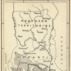
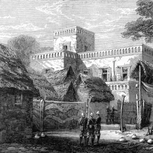
Cushion : MAP OF THE GOLD COAST, 1895. The Gold Coast in Ghana, from an English newspaper of 1895


![]()
Home Decor from Granger
MAP OF THE GOLD COAST, 1895. The Gold Coast in Ghana, from an English newspaper of 1895
MAP OF THE GOLD COAST, 1895.
The Gold Coast in Ghana, from an English newspaper of 1895
Granger holds millions of images spanning more than 25,000 years of world history, from before the Stone Age to the dawn of the Space Age
Media ID 12321098
1895 Border British Empire Coast Colonialism Colony Ashanti Ghanian
Cushion
Refresh your home decor with a beautiful full photo 16"x16" (40x40cm) cushion, complete with cushion pad insert. Printed on both sides and made from 100% polyester with a zipper on the bottom back edge of the cushion cover. Care Instructions: Warm machine wash, do not bleach, do not tumble dry. Warm iron inside out. Do not dry clean.
Accessorise your space with decorative, soft cushions
Estimated Product Size is 40cm x 40cm (15.7" x 15.7")
These are individually made so all sizes are approximate
Artwork printed orientated as per the preview above, with landscape (horizontal) or portrait (vertical) orientation to match the source image.
FEATURES IN THESE COLLECTIONS
> Africa
> Ghana
> Related Images
> Maps and Charts
> British Empire Maps
> Maps and Charts
> Related Images
> Granger Art on Demand
> Maps
EDITORS COMMENTS
This print showcases a historical artifact, the "Map of the Gold Coast, 1895" originating from an English newspaper. The Gold Coast, now known as Ghana, is depicted during the late 19th century when it was under British colonial rule. This map provides a glimpse into the intricate borders and geographical features of this West African region at that time. The image highlights various significant elements such as the Ashanti Kingdom, which played a crucial role in resisting British colonization. It also reveals neighboring territories controlled by French and German colonial powers during this era of intense European imperialism. As we delve into this visual representation, we are transported to an era where colonialism was at its peak and nations were vying for control over resources and land across Africa. The map serves as a reminder of how political boundaries were redrawn and reshaped during this period. With its detailed depiction of rivers like Kwahu River flowing through the region, this print offers valuable insights into both physical geography and human history. It encapsulates not only the turn of the century but also signifies a pivotal moment in Ghanaian history when it transitioned from being an independent kingdom to becoming part of the vast British Empire. Overall, this print stands as a testament to our shared global history while shedding light on one specific chapter in Ghana's past - one that continues to shape its present-day identity.
MADE IN AUSTRALIA
Safe Shipping with 30 Day Money Back Guarantee
FREE PERSONALISATION*
We are proud to offer a range of customisation features including Personalised Captions, Color Filters and Picture Zoom Tools
SECURE PAYMENTS
We happily accept a wide range of payment options so you can pay for the things you need in the way that is most convenient for you
* Options may vary by product and licensing agreement. Zoomed Pictures can be adjusted in the Cart.