Cushion > Europe > United Kingdom > England > Maps
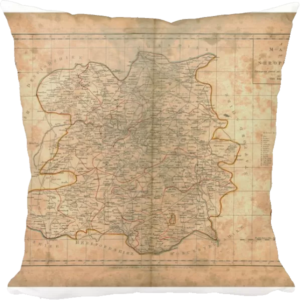
Cushion : A Map of Shropshire, c1788. Artists: John Haywood, Edward Sudlow
![]()

Home Decor from Heritage Images
A Map of Shropshire, c1788. Artists: John Haywood, Edward Sudlow
A Map of Shropshire, c1788
Heritage Images features heritage image collections
Media ID 14992215
Border County Edward Haywood Shropshire Inset Titled
Cushion
Refresh your home decor with a beautiful full photo 16"x16" (40x40cm) cushion, complete with cushion pad insert. Printed on both sides and made from 100% polyester with a zipper on the bottom back edge of the cushion cover. Care Instructions: Warm machine wash, do not bleach, do not tumble dry. Warm iron inside out. Do not dry clean.
Accessorise your space with decorative, soft cushions
Estimated Product Size is 40cm x 40cm (15.7" x 15.7")
These are individually made so all sizes are approximate
Artwork printed orientated as per the preview above, with landscape (horizontal) or portrait (vertical) orientation to match the source image.
FEATURES IN THESE COLLECTIONS
> Europe
> United Kingdom
> England
> Maps
> Europe
> United Kingdom
> England
> Shropshire
> Related Images
> Maps and Charts
> Related Images
EDITORS COMMENTS
This print showcases a remarkable piece of history: "A Map of Shropshire, c1788". Created by talented artists John Haywood and Edward Sudlow, this map offers a close-up view of the English county. The intricate details and precise engraving transport us back to the 18th century, allowing us to explore the borders, locations, and text that make up this British gem. The print collector responsible for preserving this invaluable artifact has done an exceptional job in capturing every nuance. The clarity and quality of the image are truly commendable, making it easy for viewers to appreciate the artistry behind this historical map. As we examine each inch closely, we can't help but be amazed at how much information was meticulously included within its borders. Shropshire's rich heritage is beautifully depicted through this print. It serves as a testament to Britain's love affair with cartography during the 18th century when maps were not only functional tools but also works of art. This particular map stands out with its elegant title inset and carefully crafted typography. Whether you have a personal connection to Shropshire or simply appreciate British history, this print is sure to captivate your imagination. Its timeless beauty transports us back centuries ago while reminding us of our enduring fascination with geography and exploration.
MADE IN AUSTRALIA
Safe Shipping with 30 Day Money Back Guarantee
FREE PERSONALISATION*
We are proud to offer a range of customisation features including Personalised Captions, Color Filters and Picture Zoom Tools
SECURE PAYMENTS
We happily accept a wide range of payment options so you can pay for the things you need in the way that is most convenient for you
* Options may vary by product and licensing agreement. Zoomed Pictures can be adjusted in the Cart.

